Typhoon Betty weakens; Signal No. 2 still up in Batanes, parts of Cagayan
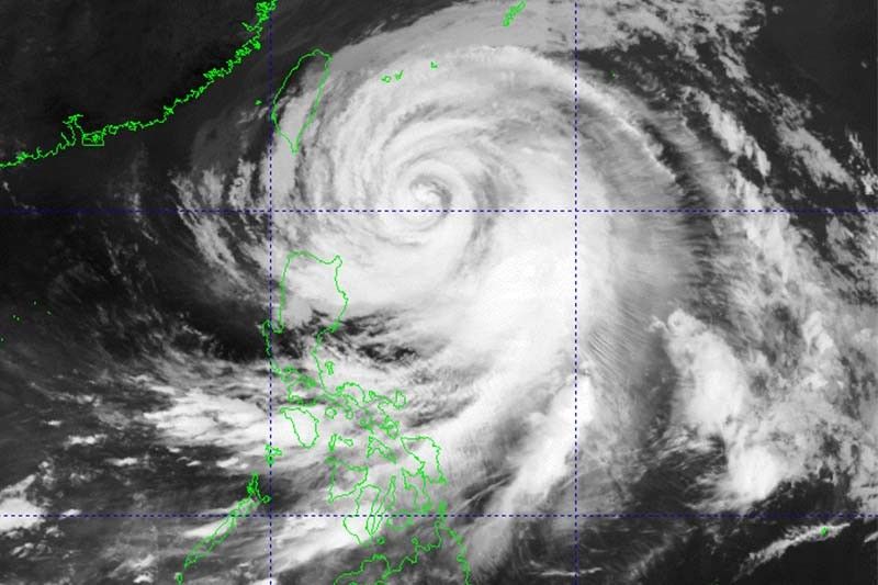
MANILA, Philippines (Updated 11:48 a.m.) — Typhoon Betty (Mawar) weakened while moving over the waters east of Batanes, but it would continue to bring heavy rain and strong winds, state weather bureau PAGASA said Tuesday morning.
Betty was last seen 315 kilometers east of Basco, Batanes with peak winds of 150 km per hour and gusts 185 kph. It was moving west northwest at 10 kph.
According to PAGASA, the typhoon is forecast to weaken steadily over the next five days due to cooler ocean waters, dry air intrusion, and increasing vertical wind shear.
Tropical Cyclone Wind Signals are still hoisted in parts of Luzon.
Wind Signal No. 2 (Winds between 62 kph and 88 kph expected in at least 24 hours that may cause minor to moderate impacts)
• Batanes
• Northeastern portion of Cagayan (Santa Ana, Gonzaga) including Babuyan Islands
Wind Signal No. 1 (Winds between 39 kph and 61 kph expected in at least 36 hours that may cause minimal to minor impacts, and intermittent rains within 36 hours)
• Rest of mainland Cagayan
• Northern and eastern portions of Isabela (Santo Tomas, Santa Maria, Quezon, San Mariano, Dinapigue, Delfin Albano, San Pablo, Ilagan City, Benito Soliven, Tumauini, Cabagan, Palanan, Quirino, Divilacan, Gamu, Maconacon, Naguilian, Mallig)
• Eastern portion of Ilocos Norte (Piddig, Bangui, Vintar, Marcos, Pagudpud, Banna, Adams, Carasi, Dingras, Solsona, Dumalneg, Nueva Era)
• Apayao
• Northern portion of Kalinga (City of Tabuk, Balbalan, Pinukpuk, Rizal)
• Northeastern portion of Abra (Tineg, Lacub, Malibcong)
What to expect
According to PAGASA, Batanes, the eastern portion of Babuyan Islands, the northeastern portion of mainland Cagayan, Ilocos Norte, Ilocos Sur, and the northern portion of La Union may experience up to 100 millimeters of rainfall until Wednesday morning.
This may trigger floods and landslides, especially in areas that are highly susceptible to these hazards and in localities that experienced considerable amounts of rainfall recently.
The southwest monsoon (habagat) enhanced by Betty will dump heavy rain to Occidental Mindoro, Antique and northern portion of Palawan until Friday morning.
The enhanced southwest monsoon and the outer periphery of the typhoon circulation will bring occasional gusts in the following areas in the next 24 hours:
• Bicol Region
• Western Visayas
• Aurora
• Quezon
• Mindoro provinces
• Marinduque
• Romblon
• Northern Samar
• Rest of Cordillera Administrative Region and Ilocos Norte
Betty may be downgraded into a severe tropical storm late Thursday or early Friday, and into a tropical storm late Friday or early Saturday. A faster weakening rate is not ruled out given the effect of dry air intrusion on the typhoon, weather forecasters noted.
The cyclone is projected to leave the Philippine Area of Responsibility late Thursday or early Friday morning.
Forecast position
• May 30, 2023 8:00 PM - 320 km east of Itbayat, Batanes
• May 31, 2023 8:00 AM - 335 km east northeast of Itbayat, Batanes
• May 31, 2023 8:00 PM - 370 km east northeast of Itbayat, Batanes
• Jun 1, 2023 8:00 AM - 475 km northeast of Itbayat, Batanes
• Jun 1, 2023 8:00 PM - 640 km northeast of Itbayat, Batanes
• Jun 2, 2023 8:00 AM - 820 km northeast of Extreme Northern Luzon (outside PAR)
• Jun 3, 2023 8:00 AM - 1,170 km northeast of Extreme Northern Luzon (outside PAR)


- Latest
- Trending