Signal No. 2 up over several areas in North Luzon due to 'Maring' winds
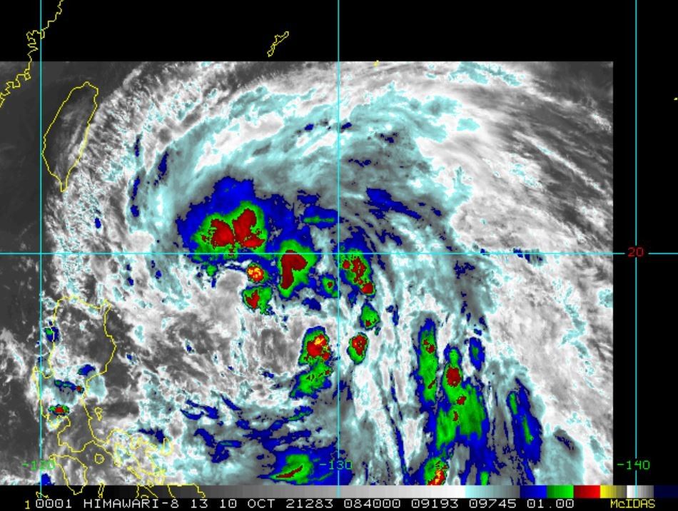
MANILA, Philippines — Signal No. 2 is now up in several parts of the country as a result of Tropical Storm Maring (international name Kompasu), which continues to move west-northwestward over the Philippine Sea west of Cagayan, government weather forecasters said Sunday evening.
According to the latest weather bulletin issued by state weather bureau PAGASA at 5 p.m. Sunday, Maring was last seen 645 kilometers east of Tuguegarao City, Cagayan, or 655 kilometers east of Aparri, Cagayan and moving west-northwestward at 20 kph.
PAGASA added that Maring is carrying maximum sustained winds of 85 kph near the center and gustiness of up to 105 kph. Its tropical cyclone winds also extend outwards up to 750 kilometers from the center.
"Maring is forecast to gradually intensify and may be upgraded to a severe tropical storm within the next 12 hours," PAGASA said.

Tropical Cyclone Wind Signal No. 2
The areas now placed under Signal No. 2 according to PAGASA include:
- Batanes,
- Cagayan including Babuyan Islands,
- the northern portion of Isabela (Santa Maria, Quezon, Cabagan, Delfin Albano, Santo Tomas, Tumauini, Maconacon, San Pablo, Divilacan, Palanan, Ilagan City),
- Apayao,
- the northern portion of Kalinga (Balbalan, Pinukpuk, Rizal, City of Tabuk),
- and the northeastern portion of Ilocos Norte (Pagudpud, Adams, Dumalneg, Bangui, Vintar, Carasi)
"Damaging gale-force to storm-force winds" are expected within 24 hours in these areas, Pagasa said.
Tropical Cyclone Wind Signal No. 1
In the following areas under Signal No. 1, strong winds will be "prevailing" or expected within 36 hours:
- The rest of Ilocos Norte
- Ilocos Sur
- La Union
- Pangasinan
- Abra
- the rest of Kalinga
- Mountain Province
- Ifugao
- Benguet
- the rest of Isabela
- Quirino
- Nueva Vizcaya
- the northern and central portion of Aurora (Dilasag, Dinalungan, Casiguran, Dipaculao, Maria Aurora, Baler)
- the northern portion of Nueva Ecija (Carranglan, Lupao, Pantabangan, San Jose City)
- and Catanduanes
- Eastern Samar
- the eastern portion of Northern Samar
- (San Roque, Pambujan, Las Navas, Catubig, Laoang, Mapanas, Lapinig, Gamay, Palapag, Mondragon, Silvino Lobos)
- and the eastern portion of Samar
- (Matuguinao, San Jose de Buan, Hinabangan, Paranas)

Tropical Cyclone Wind Signals hoisted in other areas have since been lifted.
"The possibility of a landfall over mainland Luzon is not ruled out at this time...the storm will continue to move westward through the remainder of the forecast period and may exit the Philippine Area of Responsibility by Tuesday morning or afternoon."
— Franco Luna


- Latest
- Trending