Signal No. 2 up in 4 areas as ‘Bising’ speeds up and gains strength
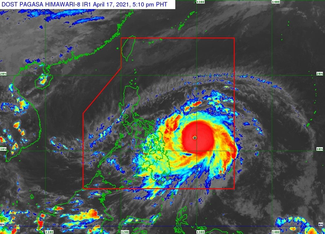
MANILA, Philippines — State weather bureau PAGASA hoisted Signal No. 2 over four areas Saturday afternoon as Typhoon Bising (international name: Surigae) slightly accelerated and intensified as it moved over the Philippine Sea.
Bising, last spotted 460 kilometers east of Guian, Eastern Samar moving west northwestward at 25 kilometers per hour (kph), now packs winds of up to 195 kph near the center and gusts of up to 240 kph.
PAGASA warned that with the uncertainty of Bising’s track, it may still shift westward and cause “potentially significant impacts” over the eastern portions of southern Luzon and Visayas.
Signal warnings
Signal No. 2
Luzon
- Catanduanes
Visayas
- Northern Samar
- Eastern Samar
- Samar
Signal No. 1
Luzon
- Sorsogon
- Albay
- Eastern portion of Camarines Sur
- Calabanga
- Naga City
- Pili
- Bula
- Bombon
- Magarao
- Canaman
- Gainza
- Camaligan
- Milaor
- Minalabac
- Tinambac
- Siruma
- Lagonoy
- Goa
- Tigaon
- Ocampo
- Baao
- Iriga City
- Nabua
- Balatan
- Bato
- Buhi
- Sagnay
- San Jose
- Garchitorena
- Presentacion
- Caramoan
- San Fernando
- Eastern portion of Masbate including Ticao Island
- Baleno
- Masbate City
- Mobo
- Uson
- Dimasalang
- Palanas
- Cataingan
- Pio V. Corpuz
Visayas
- Biliran
- Leyte
- Southern Leyte
- Camotes Islands
Mindanao
- Dinagat Islands
- Surigao del Norte (including Siargao and Bucas Grande Islands)
- Surigao del Sur
What to expect
"Bising" is forecast to further intensify and peak tomorrow packing 205 kph winds.
Areas under Signal No. 2 can expect winds of at least 61 kph to 120 kph in at least 24 hours, while areas under Signal No. 1 should be prepared for winds of 30 kph to 60 kph and intermittent rains within 36 hours.
Moderate to heavy with at times intense rains are expected over these areas starting Sunday, April 18:
- Eastern Visayas
- Bicol region
- Southern portion of Quezon
The same conditions are forecast for Monday, April 19 in these areas:
- Northern Samar
- Bicol region
- Southern portion of Quezon
Rough to high seas:
- Eastern seaboards of Luzon
- Areas where a tropical cyclone warning signal is up
Rought to very rough seas:
- Remaining seaboards of northern Luzon
- Eastern seaboards of Mindanao


- Latest
- Trending