Parts of Mindanao under Signal No. 1 due to Tropical Storm Auring
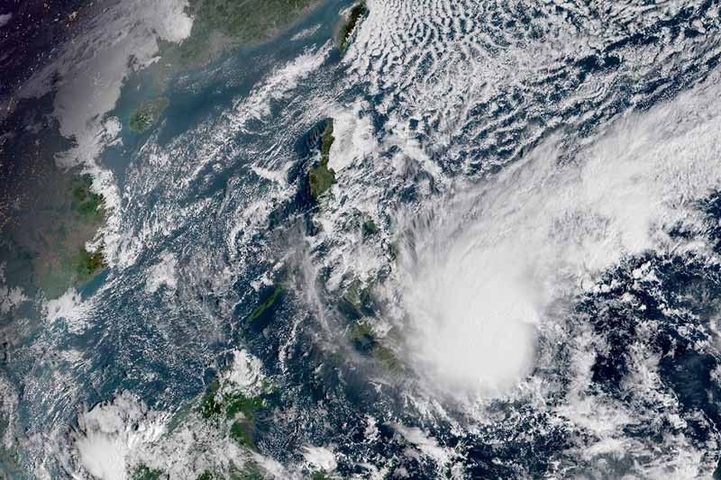
MANILA, Philippines — State weather bureau PAGASA hoisted Tropical Cyclone Wind Signal No. 1 over parts of Mindanao as Tropical Storm Auring (international name: Dujuan) slowly moved closer to the country’s landmass.
Weather forecasters placed the following areas under TCWS No. 1, which means winds of 30 to 60 kilometers per hour or intermittent rains may be experienced there within 36 hours:
- Davao Oriental
- Eastern portion of Davao de Oro (Pantukan, Maragusan, New Bataan, Compostela, Monkayo)
- Southeastern portion of Agusan del Sur (San Francisco, Rosario, Bunawan, Trento, Santa Josefa)
- Southern portion of Surigao del Sur (Bayabas, Cagwait, Marihatag, San Agustin, Lianga, Barobo, Tagbina, Hinatuan, Bislig City and Lingig)
More areas in Caraga and Davao region may be placed under TCWS No. 1 in the next bulletin, which will be issued at 11 a.m.
The center of Auring was last spotted 595 km east southeast of Hinatuan, Surigao del Sur. It is moving almost stationary.
The tropical storm packed peak winds of 75 kph near the center and gusts of up to 90 kph.
PAGASA said Auring will head generally westward or west southwestward slowly over the next 24 hours before turning northwestward Saturday morning.
It is projected to make landfall over the eastern coast of Caraga on Sunday and traverse the region as well as Visayas and MIMAROPA.
Auring may intensify into a severe tropical storm in the next 48 hours. But it is expected to weaken while crossing the archipelago due to “significant terrain interaction and dry air intrusion from the northeast monsoon.”
Rains
PAGASA said the tropical storm still has no direct effect on the Philippine landmass but its trough or extension will bring rains over parts of Mindanao.
Light to moderate with at times heavy rainshowers will affect Caraga, Davao Oriental, Davao de Oro and Davao del Norte until early Saturday morning.
Between Saturday morning and Sunday morning, Auring will dump moderate to heavy with at times intense rains over Caraga, Davao Oriental and Davao de Oro, while moderate to heavy rains over Eastern Visayas, Misamis Oriental, Camiguin, Bukidnon and Davao del Norte.
Light to moderate with at times heavy rains will be experienced in the rest of Visayas, rest of Northern Mindanao, Albay, Sorsogon, Catanduanes, Masbate, Lanao del Sur, Cotabato and Davao City.
Forecast position
- Saturday morning: 395 km east southeast of Hinatuan, Surigao del Sur
- Sunday morning: 230 km east southeast of Surigao City, Surigao del Norte
- Monday morning: 60 km east of Roxas City, Capiz
- Tuesday morning: 225 km west of Calapan City, Oriental Mindoro
- Wednesday morning: 330 km west of Subic Bay
— Gaea Katreena Cabico


- Latest
- Trending