'Ulysses' becomes typhoon ahead of landfall; Signal No. 3 up over parts of Luzon
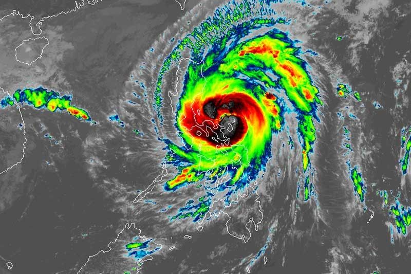
MANILA, Philippines — Several areas in Luzon were placed under Tropical Cyclone Wind Signal No. 3 Wednesday afternoon due to "Ulysses", the country’s 21st tropical cyclone this year, which strengthened into typhoon while approaching the Quezon-Aurora area.
"Ulysses" (international name: Vamco) reached typhoon category at 8 a.m. It now packs maximum sustained winds of 125 kilometers per hour near the center from the previous 110 kph and gusts of up to 155 kph from the previous 125 kph.
PAGASA warned that “destructive winds and intense with at times torrential rainfall” associated with the typhoon’s eyewall and its inner rainbands will be experienced over the northern portions of Catanduanes, Camarines Sur and Camarines Norte—areas battered by Super Typhoon Rolly—and over Aurora and northern portion of Quezon this evening until early Thursday morning.
Esperanza Cayanan, chief of PAGASA's weather division, said this evening would be the most critical period as she urged the public to prepare ahead of the typhoon's landfall.
"Ulysses will make landfall this evening in Quezon... We should not be complacent, we should not act only when it is raining heavily because it's hard to evacuate when it's dark in the evening," Cayanan said in a briefing midday.
PAGASA raised storm signals over several parts of Luzon and Visayas
TCWS No. 3 (Destructive typhoon-force winds)
- Southern portion of Aurora (Dipaculao, Baler, Maria Aurora, San Luis, Dingalan)
- Southern portion of Nueva Ecija (Bongabon, Gabaldon, General Tinio, Laur, Palayan City, Cabanatuan City, Santa Rosa, Peñaranda, Gapan City, San Leonardo, Jaen, San Antonio, San Isidro, Cabiao)
- Eastern portion of Pampanga (Candaba, Arayat, Santa Ana, Mexico, San Luis, San Simon, San Fernando City, Santo Tomas, Apalit, Minalin, Bacolor, Santa Rita, Guagua, Macabebe, Masantol, Sasmuan, Lubao)
- Bulacan
- Metro Manila
- Cavite
- Laguna
- Rizal
- Northern and central portions of Quezon (General Nakar, Infanta, Real, Mauban, Sampaloc, Lucban, Tayabas City, Sariaya, Candelaria, Dolores, Tiaong, San Antonio, Lucena City, Pagbilao, Atimonan, Padre Burgos, Unisan, Agdangan, Gumaca, Plaridel, Pitogo, Macalelon, Lopez, General Luna, Catanauan, Buenavista, Guinayangan, Tagkawayan, Calauag, Quezon, Alabat, Perez) including Polillo Islands,
- Catanduanes
- Camarines Norte
- Northern portion of Camarines Sur (Del Gallego, Ragay, Lupi, Sipocot, Cabusao, Bombon, Calabanga, Tinambac, Siruma, Goa, Lagonoy, San Jose, Garchitorena, Presentacion, Caramoan)
TCWS No. 2 (Damaging gale- to storm-force winds)
- Central and southern portions of Quirino (Maddela, Cabarroguis, Aglipay, Nagtipunan)
- Central and southern portions of Nueva Vizcaya (Kasibu, Bambang, Kayapa, Dupax Del Norte, Dupax Del Sur, Aritao, Santa Fe, Alfonso Castaneda)
- Southern portion of Benguet (Bokod, Itogon, Tublay, La Trinidad, Sablan, Baguio City, Tuba)
- Southern portion of La Union (Burgos, Naguilian, Bauang, Caba, Aringay, Tubao, Pugo, Santo Tomas, Rosario, Agoo)
- Pangasinan
- Zambales
- Bataan
- Tarlac
- Rest of Pampanga
- Rest of Nueva Ecija
- Rest of Aurora
- Batangas
- Rest of Quezon
- Marinduque
- Northern portion of Occidental Mindoro (Paluan, Abra de Ilog) including Lubang Island
- Northern portion of Oriental Mindoro (Pola, Victoria, Naujan, Baco, Calapan City, San Teodoro, Puerto Galera)
- Rest of Camarines Sur
- Albay
- Sorsogon
- Burias and Ticao Islands
TCWS No. 1 (Strong breeze to near gale conditions)
- Isabela
- Rest of Quirino
- Rest of Nueva Vizcaya
- Kalinga
- Mountain Province
- Ifugao
- Rest of Benguet
- Abra
- Ilocos Sur
- Rest of La Union
- Rest of Occidental Mindoro
- Rest of Oriental Mindoro
- Romblon
- Rest of Masbate
- Visayas
- Northern Samar
- Northern portion of Samar (Santo Nino, Almagro, Tagapul-An, Tarangnan, Calbayog City, Santa Margarita, Gandara, Pagsanghan, San Jorge, San Jose de Buan, Matuguinao)
- Northern portion of Eastern Samar (Maslog, Dolores, Oras, San Policarpo, Arteche, Jipapad)
Hazards
Until Wednesday evening, heavy to intense with at times torrential rains will be dumped over Camarines Norte, Camarines Sur and Catanduanes. Moderate to heavy with at times intense rains will affect Albay, Sorsogon, Quezon including Polillo Islands and Burias and Ticao Islands.
Meanwhile, those living in Metro Manila and the rest of Luzon and Visayas will have light to moderate with at times heavy rains.
Between Wednesday evening and early Thursday, heavy to intense with at times torrential rains will be experienced in Camarines Norte, Camarines Sur, Metro Manila, Calabarzon, Aurora, Bulacan, Pampanga and Bataan, while moderate to heavy with at times intense rains over Cordillera Administrative Region, mainland Cagayan Valley, Catanduanes, Marinduque, northern portion of Mindoro provinces and the rest of Central Luzon.
The rest of Luzon and Visayas will have light to moderate with at times heavy rains.
“Flooding (including flashfloods), rain-induced landslides, and sediment-laden streamflows (i.e. lahar) may occur during heavy or prolonged rainfall especially in areas that are highly or very highly susceptible to these hazards and/or those that received significant antecedent rainfall,” PAGASA warned.
The weather bureau also said there is high risk of storm surge with height of up to 3 meters over the coastal areas of Quezon including Polillo Islands, Camarines Norte, Catanduanes, and the northern and eastern coastal areas of Camarines Sur.
Meanwhile, there may be storm surge of up to 2 meters over the coastal areas of La Union, Pangasinan, Isabela, Zambales, Aurora, Bataan, Pampanga, Bulacan, Metro Manila, Cavite, Batangas, northern portions of Mindoro Provinces including Lubang Island, Marinduque, Romblon, Masbate including Ticao and Burias Islands, Albay, and Sorsogon, and the remaining coastal areas of Camarines Sur.
“These storm surges, which may be accompanied by swells and/or breaking waves near the coast, can cause life-threatening and damaging coastal inundation. Moreover, there is also a moderate risk of seiche or storm surge over the coastal areas surrounding Laguna de Bay,” PAGASA said.
There will be also rough to very high seas (2.5 to 10 m) over the seaboards of areas under TCWS and the eastern seaboard of Eastern Samar currently not under TCWS No. 1, making sea travel risky for all types of seacrafts.
Track and intensity
At 10 a.m., "Ulysses" was located 100 km north of Virac, Catanduanes and was heading west at 20 kph.
The typhoon is projected to pass over the seas north of Catanduanes between Wednesday morning and afternoon and north of Camarines provinces between Wednesday afternoon and evening. These areas may fall within the inner rainbands or eyewall of Ulysses during during its passage.
It is forecast to make landfall over Polillo Islands and mainland Quezon between Wednesday evening and early Thursday morning. Ulysses may attain its peak intensity of 130 to 155 kph ahead of landfall.
Then, it will cross Central Luzon and emerge over the western seaboard of Zambales between Thursday morning and afternoon.
Ulysses is expected to weaken as it moves across mainland Luzon due to the presence of the Sierra Madre and Zambales Mountain Ranges. While it may weaken, it is expected to remain a typhoon.
It may leave the Philippine Area of Responsibility Friday.
Forecast positions
- Thursday morning: over the coastal waters of Botolan, Zambales
- Friday morning: 470 km west of Iba, Zambales
- Saturday morning: 910 km west of Central Luzon (outside PAR)


- Latest
- Trending