Signal No. 3 up in Catanduanes as ‘Rolly’ approaches closer to land

MANILA, Philippines — PAGASA hoisted Saturday morning Signal Number 3 over Catanduanes as Typhoon Rolly approached closer to land.
The state weather bureau is warning that winds between 121 to 170 kilometers per hour (kph) may be expected in at least 18 hours in Catanduanes, where the storm’s eye is forecast to pass very close on Sunday morning.
More areas are also under Signal Number 2, where winds between 61 to 120 kph are expected in at least 24 hours. These areas are:
- The central and southern portions of Quezon including Polillo Islands
- Camarines Norte
- Camarines Sur
- Albay
- Sorsogon
- Burias and Ticao islands
- Marinduque
- Northern Samar
Meanwhile, these areas are under Signal Number 1, where winds between 30 to 60 kph and intermittent rains are expected in at least 36 hours:
- Metro Manila
- The rest of Masbate
- The rest of Quezon
- Rizal
- Laguna
- Cavite
- Batangas
- Romblon
- Occidental Mindoro including Lubang Island
- Oriental Mindoro
- Bulacan
- Pampanga
- Bataan
- Zambales
- Tarlac
- Nueva Ecija
- Aurora
- Pangasinan
- La Union
- Benguet
- Ifugao
- Nueva Vizcaya
- Quirino
- Southern portion of Isabela
- Northern portion of Samar
- Northern portion of Eastern Samar
- Biliran
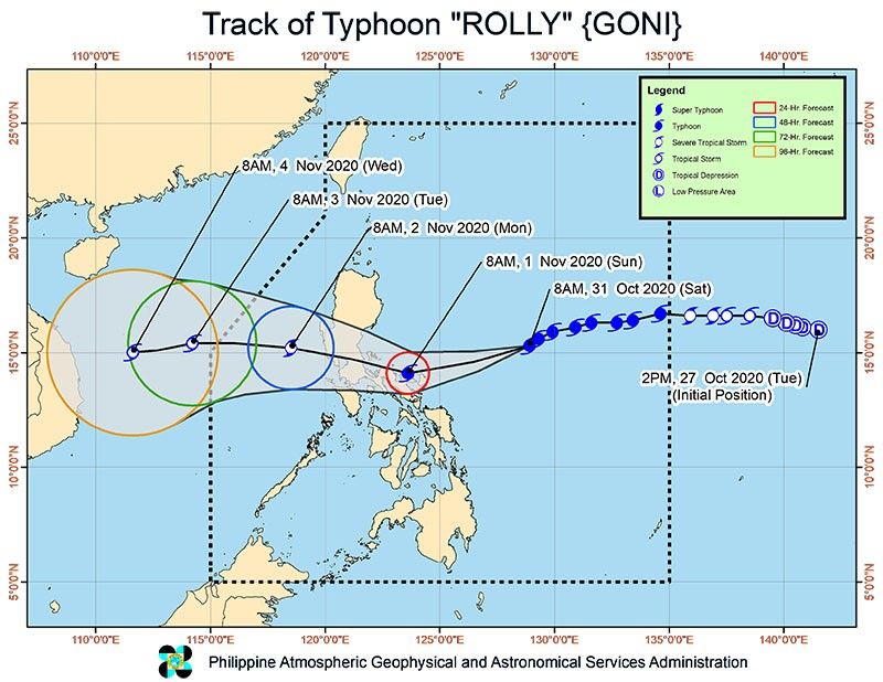
“Rolly,” last spotted 480 kilometers east northeast of Virac, Catanduanes, packs 215 kph winds near the center and gusts of up to 265 kph. A storm with winds of 220 kph and above is already classified by PAGASA as a super typhoon.
The Joint Typhoon Warning Center (JTWC), the United States Navy’s weather bureau, already classifies “Rolly” as a super typhoon, with winds of up to 286 kph and gusts of up to 351 kph.
The difference between the JTWC and PAGASA’s classification lies in their measurement of cyclones — the former observes the US’ standard of one-minute maximum sustained winds, while the local weather bureau follows the World Meteorological Organization's 10-minute measuring guideline.
Regardless of what the storm is called, “Rolly” is already the strongest storm on earth so far this year, with PAGASA expecting it to pack winds between 185 to 205 kph by the time it grazes the Bicol region and makes landfall over Quezon on Sunday afternoon.
The typhoon’s eye is projected to pass very close to Catanduanes, the Calaguas Islands, and very close to mainland Camarines provinces Sunday morning. Its eye will pass over Polillo Islands and mainland Quezon Sunday afternoon.
PAGASA said it is still not ruling out the possibility that “Rolly” will make landfall over Catanduanes and Camarines provinces due to the proximity of the typhoon’s track to the Bicol region.
PAGASA warned that there is a “moderate to high risk” of a storm surge up to one floor high in the northern coastal areas of Quezon including Polillo Islands and over six feet high in the coastal areas of Aurora, Marinduque, Bicol region, and Northern Samar and the other coastal areas of Quezon.
“Violent winds and intense rainfall” are expected over Catanduanes, Camarines Norte, and the northern portion of Camarines Sur beginning early Sunday morning until the afternoon. The same conditions are forecast to hit Quezon and the southern portion of Aurora Sunday afternoon until evening.
Heavy to intense rains are expected over Metro Manila, Bicol Region, Calabarzon, central Luzon, Marinduque, and the northern portions Occidental Mindoro and Oriental Mindoro beginning early Sunday morning, while moderate to heavy rains will be experienced over Cagayan Valley, Cordillera Administrative Region, Ilocos Region, Romblon, and the rest of Occidental Mindoro and Oriental Mindoro.
Flooding, landslides and lahar flows may occur, especially in areas susceptible to these hazards, PAGASA warned.
Forecast position
- 24 hour (Sunday morning): 70 km east of Daet, Camarines Norte
- 48 hour (Monday morning):160 km west of Iba, Zambales
- 72 hour (Tuesday morning): 620 km west of Iba, Zambales (outside PAR)
- 96 hour (Wednesday morning):900 km west of central Luzon (outside PAR)
- Latest
- Trending


