'Pepito' keeps strength as it moves toward Aurora for landfall
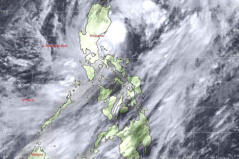
MANILA, Philippines (Updated 8:50 p.m.) — Tropical Storm Pepito has kept its strength as it continues to endanger Aurora province with a landfall on Tuesday night, state weather bureau PAGASA said.
Weather forecasters in an 8 p.m. bulletin said Pepito was last seen at 70 km east of Baler, Aurora as it continues to move westward at 25 kph.
It has maintained its maximum sustained winds of 75 kph near the center, and gustiness of up to 90 kph.
Tropical cyclone wind signals are still up over the following provinces, with more areas now under Signal No. 1
Signal No. 2
- La Union
- Ifugao
- Benguet
- Nueva Vizcaya
- Quirino
- Pangasinan
- Nueva Ecija
- Tarlac
- Aurora
- portion of Isabela (Palanan, San Mariano, Benito Soliven, Naguilian, Gamu, Burgos, San Manuel, Aurora, Cabatuan, Luna, Reina Mercedes, Cauayan City, Dinapigue, San Guillermo, Angadanan, Alicia, San Mateo, Ramon, San Isidro, Echague, San Agustin, Jones, Santiago City, Cordon)
- southern portion of Ilocos Sur (Sugpon, Alilem, Tagudin)
- northern portion of Zambales (Iba, Palauig, Masinloc, Candelaria, Santa Cruz, Botolan, Cabangan)
- northern portion of Quezon (General Nakar)
Signal No. 1
- Abra
- Kalinga
- Mountain Province
- Bataan
- Metro Manila
- Rizal
- northern portion of Camarines Norte (Paracale, Jose Panganiban, Capalonga, Vinzons)
- Catanduanes rest of northern portion of Quezon (Infanta, Real)
- the rest of Ilocos Sur
- the rest of Isabela
- the rest of Pampanga
- the rest of Bulacan
- the rest of Zambales
Moderate to heavy rains are still expected Tuesday night until Wednesday morning over Central Luzon, MIMAROPA, Camarines Norte, Quezon, mainland Cagayan, La Union aside from areas under the tropical cyclone wind signal.
Metro Manila and the rest of Luzon, meanwhile, will experience light to moderate with occasional heavy rains along with Western Visayas, Zamboanga Peninsula and Bangsamoro.
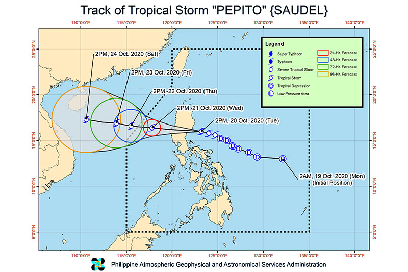
Forecast Position
- Wednesday evening: 335 km West of Dagupan City, Pangasinan
- Thursday evening: 555 km West of Dagupan City, Pangasinan
- Friday evening: 735 km West of Sinait, Ilocos Sur
- Saturday evening: 1,080 km West of Northern Luzon
— Christian Deiparine


Follow this thread for updates on cyclone Pepito (international name Saudel).
Pepito has intensified into a severe tropical storm at 2 p.m. on Wednesday, state weather bureau PAGASA says.
The weather disturbance is forecast to move west-northwestward and may exit the Philippine Area of Responsibility by Thursday.
No typhoon cyclone wind signal is in effect.
Tropical Storm 'Pepito' has intensified slightly and now has maximum sustained winds of 85 km/h near the center and gustiness of up to 105 km/h.
The storm has been forecast to gain strength at it moves over the West Philippine Sea and may develop into a severe tropical storm, Pagasa also says.
As of 10 a.m., 'Pepito' was 210 km west of Dagupan City, Pangasinan.
Only the western portion of Pangasinan (Bolinao, Anda, Bani, Agno, Alaminos City, Mabini, Burgos, Dasol, Sual, Labrador, Infanta) remains under Tropical Cyclone Wind Signal No. 1.
'Pepito' was 115 kilometers northwest of Dagupan City and 120 km west northwest of Baguio City as of 7 a.m., Pagasa says in its 8 a.m. bulletin.
The tropical storm is moving west northwest at 30 km/h and has maximum sustained winds of 75 km/h near the center and gustiness of up to 90 km/h, the weather bureau also says.
Tropical Cyclone Wind Signal No. 2 is up over the following areas:
- La Union
- Northern portion of Zambales (Iba, Palauig, Masinloc, Candelaria, Santa Cruz)
- Western portion of Pangasinan (Bani, Anda, Bolinao, Agno, Dasol, Burgos, Alaminos City, Mabini, Sual, Infanta, Bugallon, Labrador, Aguilar, Mangatarem, Urbiztondo, Basista, Malasiqui, San Fabian, Pozzorubio, Sison, Laoac, Urdaneta City, Manaoag, San Jacinto, Dagupan City, Mangaldan, Mapandan, Santa Barbara, San Carlos City, Calasiao, Binmaley, Lingayen)
TCWS No. 1 is up over these areas:
- Ilocos Norte
- Ilocos Sur
- Rest of Pangasinan
- Abra
- Western portion of Kalinga (Balbalan, Pasil, Lubuagan, Tinglayan)
- Western portion of Mountain Province (Barlig, Sadanga, Bontoc, Sagada, Sabangan, Bauko, Tadian, Besao)
- Wwestern portion of Ifugao (Banaue, Hingyon, Kiangan, Tinoc, Hungduan, Asipulo)
- Benguet
- Western portion of Nueva Vizcaya (Ambaguio, Kayapa, Aritao, Santa Fe)
- Western portion of Nueva Ecija (Carranglan, Lupao, Muñoz City, Santo Domingo, Zaragoza, Aliaga, Licab, Guimba, Talugtug, Quezon, Nampicuan, Cuyapo)
- Rest of Zambales
'Pepito' is now over the Lingayen Gulf after crossing over Northern Luzon, PAGASA says, adding the tropical storm is expected to exit the Philippine Area of Responsibility by Thursday afternoon.
Tropical Cyclone Wind Signal No. 2 is up over these areas:
- Ilocos Sur
- La Union
- Pangasinan
- Benguet
- Tarlac
- Northern portion of Zambales (Iba, Palauig, Masinloc, Candelaria, Santa Cruz, Botolan, Cabangan)
TCWS No. 1 is up over the following areas:
- Ilocos Norte
- Kalinga
- Abra
- Ifugao
- Mountain Province
- Southern portion of Isabela (Palanan, San Mariano, Benito Soliven, Naguilian, Gamu, Burgos, San Manuel, Aurora, Cabatuan, Luna, Reina Mercedes, Cauayan City, Dinapigue, San Guillermo, Angadanan, Alicia, San Mateo, Ramon, San Isidro, Echague, San Agustin, Jones, Santiago City, Cordon)
- Quirino
- Nueva Vizcaya
- Aurora
- Nueva Ecija
- Bulacan
- Pampanga
- Rest of Zambales
- Bataan
PAGASA says Tropical Storm Pepito slightly intensifies as it increases its threat over Aurora province.
It is expected to make landfall over the coast of Aurora between 6:00 p.m. to 10:00 p.m. Tuesday.


- Latest
- Trending