Signal No. 1 still up over 3 areas in Cagayan Valley due to ‘Carina’
MANILA, Philippines (Update 2; 2:46 p.m.) — Tropical depression Carina will bring rains over Luzon, including Metro Manila, Monday as it moves northwest, PAGASA said.
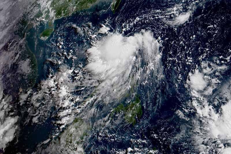
In a 2 p.m. bulletin, the state weather bureau said “Carina” was located at 200 kilometers east northeast of Tuguegarao City, Cagayan or 200 km east of Aparri, Cagayan bearing peak winds of 45 km per hour near the center and gusts of up to 55 kph.
It is heading northwestward at 15 kph.
“Carina” comes at a time when the country struggles to contain the coronavirus disease pandemic that has so far infected over 50,000 people.
Tropical Cyclone Wind Signal No. 1 remains hoisted over:
• Batanes
• Babuyan Islands
• Northeastern portion of mainland Cagayan (Santa Ana, Gonzaga, Santa Teresita, Buguey, Easterm Lal-lo, Eastern Gattaran and Eastern Baggao)
Winds between 30 kph and 60 kph and intermitted rains may be experienced in these areas within 36 hours.
PAGASA said residents of Cagayan including Babuyan Islands, Isabela, Abra and Ilocos Norte will have scattered to widespread moderate to heavy rains.
Meanwhile, scattered light to moderate with at times heavy rains will be experienced over the rest of Northern Luzon, Central Luzon, Metro Manila, Calabarzon, Mindoro provinces, Marinduque, Romblon, Camarines Norte and Camarines Sur.
“Flooding and rain-induced landslides may occur during heavy or prolonged rainfall especially in areas that are highly or very highly susceptible to these hazards,” PAGASA said.
It also advised those with small seacraft not to venture out over the northern and eastern seaboards of Luzon in the next 24 hours due moderate to rough seas.
The center of the tropical depression is seen to move northwestward toward the Luzon Strait, passing roughly 100 km off the northeastern tip of Luzon and near Babuyan Islands and Batanes. A landfall scenario over these areas remains a possibility considering the forecast track probability cone.
“Carina” is expected to weaken into a low pressure area on Wednesday.
Forecast positions
• Tuesday morning: 55 kph west northwest of Basco, Batanes
• Wednesday morning: 430 km north of Basco, Batanes
Tropical Depression Carina — the third tropical cyclone to enter the country this year — maintains its strength as it moves over Luzon Strait, state weather bureau PAGASA says.
At 7 a.m., the weather disturbance was located 275 kilometers east of Tuguegarao City with maximum sustained winds of 45 kph and gusts of up to 55 kph.
It is forecast to weaken into a low pressure area by Wednesday.
Tropical Depression Carina continues to move away from Batanes as it heads towards Bashi Channel and the southern portion of Taiwan, PAGASA says.
At 10 a.m., the typhoon was located 155 west of Basco, Batanes with maximum winds of 45 kph and gusts of up to 55 kph. It is moving northwestward at 25 kph.
Tropical Cyclone Wind Signal no. 1 is still hoisted over Batanes.
Tropical Cyclone Wind Signal no. 1 is still raised over Batanes as Tropical Depression Carina moves past the Balintang Channel.
State weather bureau PAGASA says Carina is now approaching the Bashi Channel.
At 7 a.m., the typhoon was located 95 kilometers west northwest of Basco, Batanes. It packs maximum winds of 45 kph and gusts of up to 55 kph. It is moving northwestward at 25 kph.
Tropical Depression Carina maintains its strength as it moves towards the Luzon Strait. It is forecast to weaken into a low pressure area by Wednesday.
At 4 p.m., the tropical depression was located 165 kilometers east northeast of Tuguegarao City, Cagayan. The weather disturbance packs winds of 45 kph and gusts of up to 55 kph. It is moving northwestward at 15 kph.
Tropical cyclone wind signal no. 1 is still raised over Batanes Babuyan Islands and the northeastern portion of mainland Cagayan (Santa Ana, Gonzaga, Santa Teresita, Buguey, Camalaniugan, Aparri, Lal-lo, Gattaran and Baggao).
Tropical Depression Carina continues to approach extreme northern Luzon, passing near Babuyan Islands and Batanes.
At 10 a.m., the typhoon was located 245 kilometers east of Tuguegarao City, Cagayan, packing maximum sustained winds of 45 kph near the center and gustiness of up to 55 kph.
Tropical Cyclone Wind Signal no. 1 is raised over Batanes, Babuyan Islands and the northeastern portion of mainland Cagayan (Santa Ana, Gonzaga, Santa Teresita, Buguey, eastern Lal-lo, eastern Gattaran and eastern Baggao).


- Latest
- Trending