6 areas in Luzon under Signal No. 3 as ‘Ambo’ crashes into land for sixth time
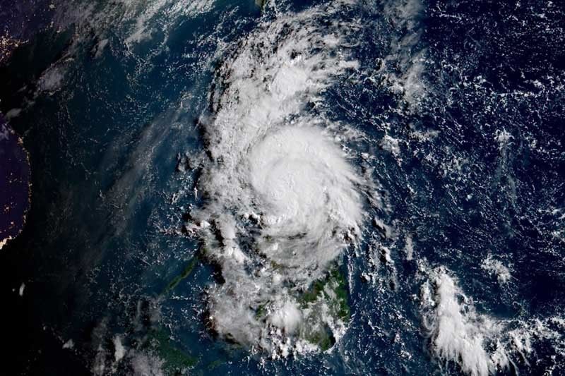
MANILA, Philippines (Updated 9:27 a.m.) — Typhoon Ambo (international name: Vongfong) made its sixth landfall over southern Quezon with violent winds and heavy rains, weather forecasters said Friday morning.
The typhoon—the first to hit the Philippines this year—forced tens of thousands to flee their homes, complicating the government’s response to the growing threat of the novel coronavirus.
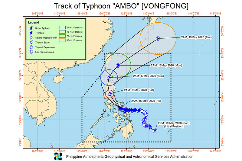
PAGASA said “Ambo” crashed into San Andres town in Quezon at 7:45 a.m. It previously made landfalls over San Policarpio in Eastern Samar, Dalupiri Island and Capul Island in Northern Samar, and Ticao Island and Burias Island in Masbate.
The eyewall of the typhoon—a powerful part of a tropical cyclone—is bringing “destructive winds and heavy to intense rainfall” over Bondoc Peninsula in Southern Quezon and Burias Island.
“Ambo” was last seen over the coastal waters of San Andres, Quezon bearing peak winds of 125 kilometers per hour and gusts of up to 165 kph. It is moving northwest at 15kph.
Tropical Cyclone Warning Signals have been hoisted over the following areas:
TCWS No. 3 (Winds between 121 kph and 170 kph in at least 18 hours)
- Western portion of Camarines Sur (Del Gallego, Ragay, Lupi, Sipocot, Cabusao, Libmanan, Pamplona, Pasacao, San Fernando, Minalabac, Bula, Balatan)
- Extreme western portion of Camarines Norte (Santa Elena)
- Burias Island
- Marinduque
- Eastern portion of Quezon (Polillo, Infanta, Real, Mauban, Pagbilao, Sampaloc, eastern Tayabas, Atimonan, Padre Burgos, Agdangan, Plaridel, Unisan, Gumaca, Pitogo, Perez, Alabat, Quezon, Tagkawayan, Calauag, Lopez, Macalelon, General Luna, Catanauan, Buenavista, Guinayangan, Mulanay, San Narciso, San Andres, San Francisco)
- Eastern portion of Laguna (Santa Maria, Famy, Siniloan, Pangil, Pakil, Mabitac, Paete, Kalayaan, Lumban, Cavinti)
TCWS No. 2 (Winds between 61 kph and 120 kph in at least 24 hours)
- Southeastern portion of Pangasinan (Mangatarem, Urbiztondo, Bayambang, Bautista, Basista, Malasiqui, Alcala, Sto. Tomas, Urdaneta, Villasis, Rosales, Asingan, Sta. Maria, Balungao, Umingan, San Quintin, Tayug, San Manuel, San Nicolas, Natividad)
- Nueva Vizcaya
- Quirino
- Aurora
- Nueva Ecija
- Tarlac
- Pampanga
- Bulacan
- Metro Manila
- Rizal
- Cavite
- Batangas
- Rest of Laguna
- Rest of Quezon
- Western portion of Masbate (Balud, Mandaon, Aroroy, Baleno, Masbate City, Mobo, Uson, Milagros) including Ticao Island
- Rest of Camarines Norte
- Rest of Camarines Sur
- Albay
- Sorsogon
- Southern portion of Catanduanes (San Andres, Virac, Bato)
- Eastern portion of Romblon (Banton, Corcuera, Calatrava, San Agustin, Romblon, Magdiwang, San Fernando, Cajidiocan)
TCWS No. 1 (Winds between 30 kph and 60 kph in at least 36 hours)
- Cagayan including Babuyan Islands
- Isabela
- Ilocos Norte
- Ilocos Sur
- Rest of Pangasinan
- Apayao
- Kalinga
- Abra
- Mountain Province
- Ifugao
- Benguet
- Zambales
- Bataan
- Oriental Mindoro
- Occidental Mindoro
- Rest of Catanduanes
- Rest of Masbate
- Rest of Romblon
- Extreme northeastern portion of Capiz (Pilar, Panay, Roxas, Ivisan)
- Northeastern portion of Iloilo (Carles, Balasan, Estancia, Batad)
- Western portion of Northen Samar (San Vicente, Capul, San Antonio, Allen, Victoria, San Isidro, Biri, Lavezares, Rosario, San Jose)
Rainfall outlook
Weather forecasters said moderate to heavy with at times intense rains over will be experienced Bicol region, Quezon, Aurora and Marinduque, Laguna, Rizal, Metro Manila, Bulacan, Nueva Ecija, Nueva Vizcaya and Quirino today.
By Saturday, residents of Cagayan Valley, Cordillera Administrative Region, Aurora and Nueva Ecija will have moderate to heavy with at times intense rains.
PAGASA warned that flooding and rain-induced landslide may happen in highly to very highly susceptible areas during heavy or prolonged rainfall.
Storm surge with height of up to two meters may be experienced over the coastal areas of Bicol region, Quezon and Aurora in the next 24 hours. Storm surge may result in “potentially life-threatening coastal inundation.”
Sea travel remains risk over the seaboards of areas under TCWS.
Forecast positions
- Saturday morning: In the vicinity of Santa Fe, Nueva Vizcaya
- Sunday morning: 50 km west southwest of Basco, Batanes
- Monday morning: 435 km northeast of Basco, Batanes
- Tuesday morning: 1,470 km northeast of extreme Northern Luzon (outside Philippine Area of Responsibility)


- Latest
- Trending