Bringing violent winds and heavy rains, 'Ambo' heads to Samar province after landfall
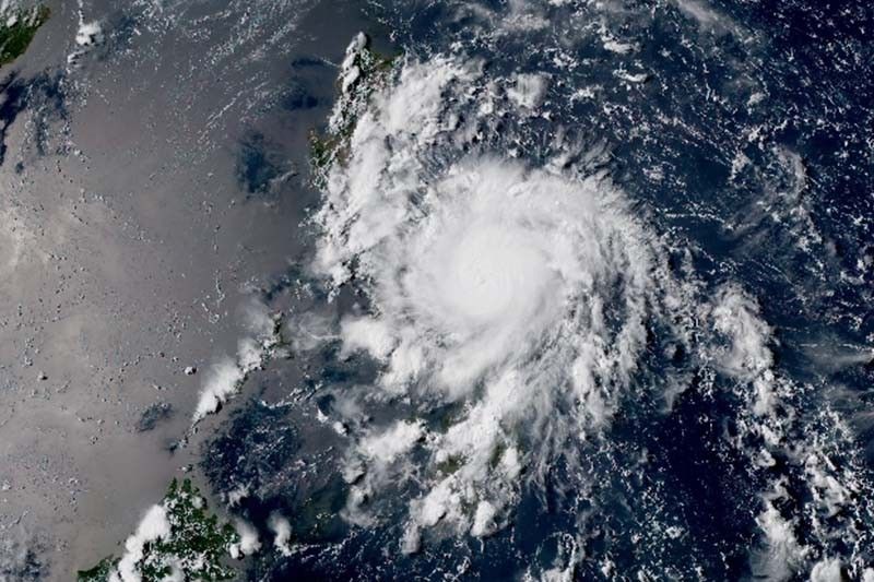
MANILA, Philippines — Typhoon Ambo (Vongfong)—the first tropical cyclone to hit the coronavirus-wracked Philippines—is now heading toward the northern portion of Samar province after making a landfall with strong winds and heavy rains.
“Ambo” made its first landfall over San Policarpio town in Eastern Samar at 12:15 p.m., state weather bureau PAGASA said Thursday afternoon.
Weather forecasters said the typhoon’s eyewall—a powerful part of a tropical cyclone—is bringing violent winds and dumping heavy to intense rains over the northern portion of Eastern Samar.
The eyewall is also projected to lash the northern portion of Samar and southern portion of Northern Samar.
At 1 p.m., the eye of “Ambo” was seen at the vicinity of Oras town in Eastern Samar packing peak winds of 155 kph and gusts of up to 190 kph. It is moving west at 15 kph.
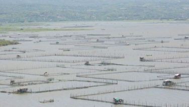
The typhoon forced the evacuation to temporary shelters of thousands who were told to stay home during the coronavirus pandemic.
PAGASA raised tropical cyclone warning signals over the following areas:
TCWS No. 3 (Winds between 121 kph and 170 kph in at least 18 hours)
- Sorsogon
- Albay
- Masbate including Ticao and Burias Islands
- Catanduanes
- Southern Portion of Camarines Sur (Cabusao, Libmanan, Pasacao, Pamplona, Canaman, Magarao, Bombon, Calabanga, Camaligan, Gainza, San Fernando, Milaor, Naga, Tinambac, Siruma, Pili, Goa, Lagonoy, Garchitorena, Minalabac, Caramoan, Presentacion, Bula, Ocampo, Tigaon, San Jose, Balatan, Nabua, Baao, Sagnay, Bato, Nabua, Iriga, Buhi)
- Northern Samar
- Northern portion of Eastern Samar (Jipapad, Arteche, Maslog, Dolores, Oras, San Policarpio, Can-avid, Sulat, San Julian, Borongan City, Maydolong)
- Northern portion of Samar (Calbayog City, Sta. Margarita, Gandara, Pagsanghan, San Jorge, Matuguinao, San Jose de Buan, Catbalogan, Jiabong, Motiong, Paranas, Tarangan, San Sebastian, Hinabangan)
- Biliran
TCWS No. 2 (Winds between 61 kph and 120 kph in at least 24 hours)
- Camarines Norte
- Rest of Camarines Sur
- Southern portion of Quezon (Mauban, Sampaloc, Lucban, Sariaya, Tayabas City, Lucena City, Pagbilao, Atimonan, Padre Burgos, Plaridel, Agdangan, Unisan, Gumaca, Pitogo, Macalelon, Lopez, Caluag, General Luna, Catanauan, Perez, Alabat, Quezon, Tagkawayan, Guinayangan, Buenavista, San Narciso, Mulanay, San Andres, San Francisco)
- Marinduque
- Northernmost portion of Leyte (Calubian, San Isidro, Tabango, Leyte, Capoocan, Carigara, Barugo, San Miguel, Babatngon, Tunga, Alangalang, Sta. Fe, Palo, Tacloban City, Jaro)
- Rest of Samar
- Rest of Eastern Samar
TCWS No. 1 (Winds between 30 kph and 60 kph in at least 36 hours)
- Aurora
- Southern portion of Nueva Ecija (General Mamerto Natividad, Palayan City, Cabanatuan, Santa Rosa, Jaen, San Isidro, San Antonio, Cabiao, Bongabon, Gabaldon, General Tinio, Laur, San Leonardo, Peñaranda, Gapan City
- Bulacan
- Metro Manila
- Cavite
- Laguna
- Batangas
- Rizal
- Rest of Quezon
- Romblon
- Bataan
- Pampanga
- Rest of northern portion of Leyte (Villaba, Kananga, Matag-ob, Palompon, Ormoc, Merida, Isabel, Ormoc City, Albuena, Pastrana, Dagami, Tanauan, Tabontabon, Tolosa, Barauen, Julita, Dulag)
- Northeastern portion of Capiz (Pilar),
- Northeastern portion of Iloilo (Carles, Balasan, Estancia, Batad)
- Northern Cebu (Medelin, Daanbantayan, Madridejos, Bantayan, Santa Fe)
Rainfall outlook
Residents of the Samar provinces, Masbate, Sorsogon and Catanduanes may experience heavy to intense rains on Thursday, while those living in Albay, Camarines Sur and the rest of Eastern Visayas will have moderate to heavy with at times intense rains.
By Friday, “Ambo” will dump heavy to intense rains over Bicol region. Moderate to heavy with at times intense rains will affect Northern Samar, Quezon, Aurora, Marinduque and Romblon.
PAGASA warned that storm surges—an abnormal rise in sea level during storms—of 2 to 4 meters may be experienced in the coastal areas of Northern Samar, Eastern Samar, Samar, Sorsogon, Albay, Catanduanes, Camarines Sur, Camarines Norte, Quezon and Aurora.
“Along with large swells, this storm surge may cause potentially life-threatening coastal inundation,” it said.
Forecast positions
- Friday morning: In the vicinity of Lopez, Quezon
- Saturday morning: In the vicinity of Tineg, Abra
- Sunday morning: 75 km northeast of Basco, Batanes
- Monday morning: 780 km northeast of Basco, Batanes
- Tuesday morning: 1,915 km northeast of Basco, Batanes (outside PAR)


- Latest
- Trending