‘Sarah’ enters Philippines, almost stationary in North Luzon
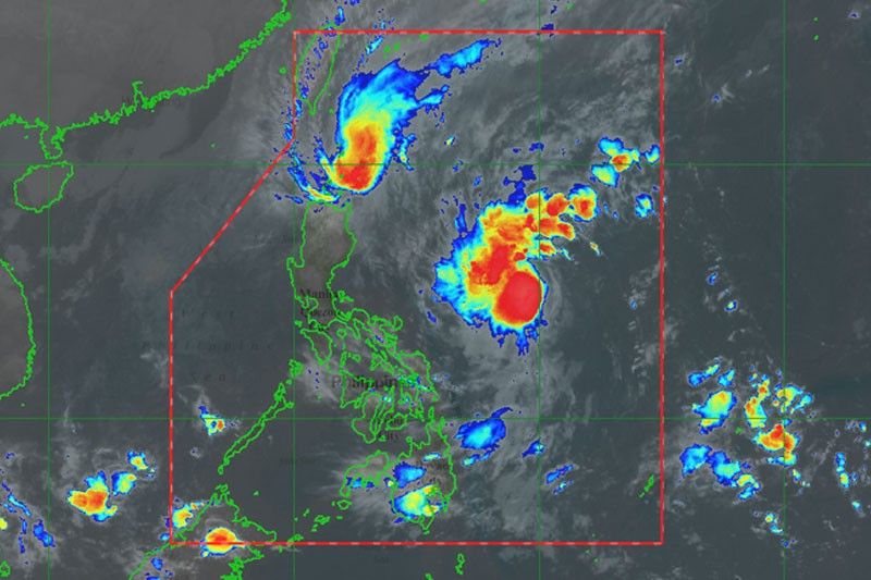
MANILA, Philippines — Tropical Depression Sarah entered the Philippines yesterday as Typhoon Ramon intensified and lingered over the coast of Cagayan, bringing heavy rains and strong winds in many provinces in Northern Luzon.
“Almost stationary” as of 4 p.m., Ramon is expected to weaken after its landfall and interaction with the cold northeast monsoon.
Ramon will continue to bring light to moderate with occasional heavy rains and strong winds over Batanes, northern portion of Cagayan including the Babuyan Islands and Apayao today.
Light to moderate with intermittent heavy rains will persist over Isabela, the rest of Cagayan, northern portion of Aurora, Kalinga and Ilocos Norte.
The state weather bureau also warned of possible storm surges of up to two meters in La Union and Pangasinan.
As of 5 p.m. yesterday, tropical cyclone warning Signal No. 3 was hoisted over the northern portion of Cagayan, including Santa Praxedes, Claveria, Sanchez Mira, Pamplona, Abulug, Ballesteros, Aparri, Calayan, Camalaniugan, Buguey, Santa Teresita, Gonzaga and Santa Ana.
Signal No. 2 was hoisted over Batanes Apayao, Kalinga, Abra, Ilocos Norte, Ilocos Sur and the rest of Cagayan.
Signal No. 1 was raised over the northern portion of Isabela, including Sta. Maria, San Pablo, Maconacon, Cabagan, Sto. Tomas, Quezon, Delfin Albano, Tumauini, Divilacan, Quirino, Roxas, Mallig, San Manuel, Burgos, Gamu and Ilagan City; Mountain Province, Benguet, Ifugao, La Union and Pangasinan.
Ramon was forecast to make landfall over the Babuyan Islands between last night and this morning, the Philippine Atmospheric, Geophysical and Astronomical Services Administration (PAGASA) said.
As of 4 p.m., the eye of the typhoon was estimated at 120 kilometers east of Calayan, Cagayan.
It packed winds of 120 kilometers per hour near the center and gustiness of up to 165 kph.
Ramon is expected to exit the country tomorrow.
Meanwhile, Sarah was spotted at 710 km east of Virac, Catanduanes, packing winds of 55 kph and gustiness of up to 70 kph as of 4 p.m.
It was moving northwest at a speed of 35 kph.
Sarah was forecast to intensify into a storm within the next 24 hours, according to weather forecaster Benison Estareja.
It was also expected to hit landmass of Cagayan tomorrow and bring light to moderate with intermittent heavy rains over Cagayan, Isabela, northern portion of Aurora, Apayao, Kalinga, and Abra.
The Cagayan Disaster Risk Reduction and Management Office (CDRRMO) said at least 5,578 people were displaced in 15 towns in the province during the onslaught of Ramon yesterday.
The CDRRMO said evacuees were from 1,899 families from Aparri, Allacapan, Pamplona, Sta. Praxedes, Sta. Ana, Gonzaga, Sta. Teresita, Camalaniugan, Lallo, Abulug, Claveria, Sta. Teresita, Baggao, Buguey and Gattaran.
Cagayan Police director Col. Ariel Quilang said authorities evacuated 656 people or 163 families in eight villages in the coastal town of Sta. Ana that were inundated by floodwaters.
The towns of Sta. Ana and Gonzaga were placed under orange rainfall warning by PAGASA. – With Raymund Catindig


- Latest
- Trending