Liwayway brings heavy rains
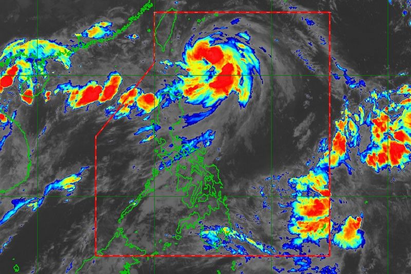
MANILA, Philippines — Severe Tropical Storm Liwayway (international name Lingling) continued to gather strength as it hovered over the Philippine Sea yesterday, bringing heavy rains and strong winds over extreme Northern Luzon.
As of 5 p.m., tropical cyclone wind signal No. 1 remained hoisted over Batanes, according to the Philippine Atmospheric, Geophysical and Astronomical Services Administration (PAGASA).
The storm remained unlikely to make landfall, however, even as the weather bureau warned residents of Batanes against strong winds.
PAGASA said the weather disturbance would continue to bring light to moderate with intermittent heavy rains over Batanes and Babuyan Islands this afternoon.
Scattered light to moderate rains to at times heavy rains will prevail over Ilocos region, Central Luzon, Metro Manila, Calabarzon (Cavite, Laguna, Batangas, Rizal and Quezon), northern portions of Palawan, including Calamian Islands, Mindoro provinces and the rest of the Cordilleras due to the southwest monsoon, which is being enhanced by the storm.
The trough or extension of Liwayway and the southwest monsoon will bring light to moderate with intermittent heavy rains over Batanes and Babuyan Islands until tomorrow afternoon.
Light to moderate rains will prevail over Ilocos, Bataan and Zambales until Friday due to the southwest monsoon.
As of 4 p.m., the center of the storm was estimated at 225 kilometers east of Basco, Batanes, packing winds of 110 kilometers per hour near the center and gustiness of up to 135 kph.
It was moving north toward Taiwan at a speed of 15 kph.
Liwayway is expected to leave the Philippine area of responsibility between tonight and tomorrow afternoon.
PAGASA reiterated its warning against rough sea conditions in the seaboards of Luzon, including Batanes.
PAGASA weather forecaster Aldczar Aurelio said Liwayway was forecast to intensify into a typhoon before it exits the country on Thursday.
Meanwhile, a new low-pressure area was spotted east of Mindanao yesterday afternoon.
It was spotted at 1,375 kilometers east of Mindanao as of 4 p.m.
Aurelio said the low-pressure area has no direct effect on the country yet. It is expected to enter the Philippine area of responsibility tomorrow afternoon.
The weather system will bring rains over Davao and Caraga regions beginning tomorrow until Friday.
The rest of the country will have generally fair weather apart from isolated rains due to thunderstorms, Aurelio said.


- Latest
- Trending