15 areas under Signal No. 1 due to Tropical Depression Jenny
MANILA, Philippines — State weather bureau PAGASA hoisted Tropical Cyclone Wind Signal No. 1 over 15 areas in Luzon on Monday afternoon due to Tropical Depression Jenny.
Weather forecasters placed the following areas under TCWS No. 1, which means winds of 30 to 60 kilometers per hour or intermittent rains may be experienced there within 36 hours:
• Cagayan
• Isabela
• Quirino
• Nueva Vizcaya
• Apayao
• Abra
• Kalinga
• Mountain Province
• Ifugao
• Benguet
• Aurora
• Nueva Ecija
• Eastern portion of Pangasinan
• Northern portion of Quezon including Polillo Island
• Catanduanes
TCWS No. 1 may be raised over Ilocos Norte, Babuyan Islands and the rest of Pangasinan in the next Severe Weather Bulletin to be issued at 11 p.m, PAGASA also said.
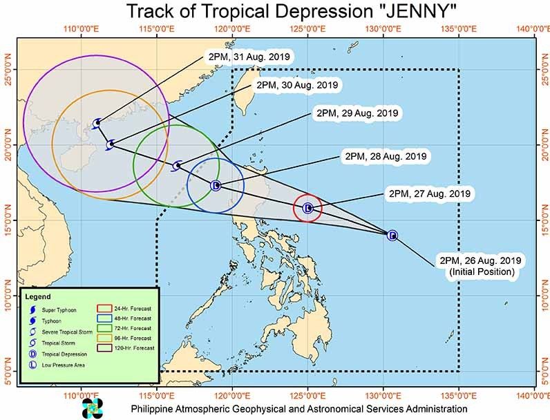
“Jenny” was last spotted 670 km east of Virac, Catanduanes with maximum sustained winds of 45 kph near the center and gusts of up to 55 kph.
The tropical depression is heading northwest at 25 kph.
“Jenny” is expected to make landfall over the Northern Luzon area. It may leave the Philippine Area of Responsibility on Thursday.
Between Monday and Tuesday afternoon, “Jenny” will bring light to moderate with intermittent heavy rains over CARAGA, Eastern Visayas and Bicol region.
Moderate to heavy rains may prevail over Cagayan, Isabela, Nueva Vizcaya, Quirino, northern Aurora, Kalinga, Abra, Mountain Province, Ifugao, Benguet, Ilocos Sur and La Union between Tuesday afternoon and Wednesday afternoon.
Meanwhile, residents of MIMAROPA, Bicol region, Western Visayas, Zamboanga Peninsula, and the rest of Ilocos region, Cordillera Administrative Region, Cagayan Valley and Central Luzon may experience light to moderate with intermittent heavy rains.
PAGASA warned that sea travel is risky over the seaboards of areas under TCWS due to potentially rough sea conditions.
Forecast positions
• Tuesday afternoon: 370 km east of Baler, Aurora
• Wednesday afternoon: 160 km west of Sinait, Ilocos Sur
• Thursday afternoon: 455 km west of Laoag City, Ilocos Norte (outside PAR)
• Friday afternoon: 935 km west northwest of Laoag City, Ilocos Norte (outside PAR)
• Saturday afternoon 1,145 km west of Basco, Batanes (outside PAR)
— Gaea Katreena Cabico


- Latest
- Trending