Goring enters Phl; new LPA forming

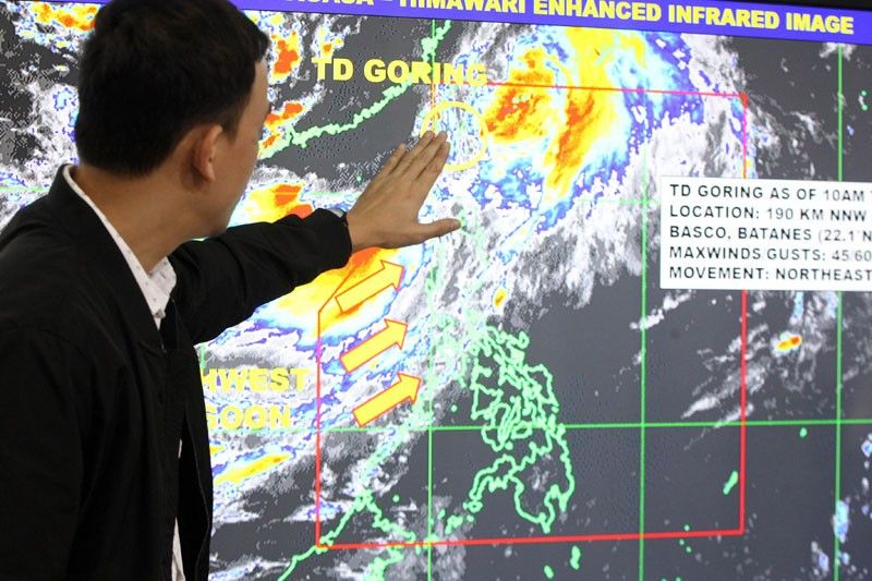
MANILA, Philippines — The low-pressure area west of Batanes developed into a tropical depression yesterday but was expected to exit the country last night after dumping moderate to heavy rains over parts of Northern Luzon.
According to the Philippine Atmospheric, Geophysical and Astronomical Services Administration (PAGASA), Tropical Depression Goring was spotted at 380 kilometers north- northeast of Basco, Batanes as of 4 p.m. yesterday.
The cyclone packed winds of 45 kilometers per hour near the center and gustiness of up to 60 kph.
It was forecast to move northeast at a speed of 30 kph.
Tropical Cyclone Wind Signal No. 1 was raised over Batanes as of 5 p.m. yesterday.
Goring was forecast to exit the Philippine area of responsibility last night.
PAGASA warned the southwest monsoon will continue to bring rains over Batanes, Ilocos region and Babuyan Group of Islands as well as in the provinces of Zambales and Bataan today that could trigger flashfloods and landslides.
Meanwhile, Metro Manila, Cordillera Administrative Region, Calabarzon, Mindoro provinces, Palawan and the rest of Central Luzon will have partly cloudy to cloudy skies with rainshowers and thunderstorms.
The rest of the country will experience partly cloudy to cloudy skies with isolated rainshowers or thunderstorms.
Tomorrow, the southwest monsoon will still bring cloudy skies with scattered rains and thunderstorms over Batanes, Ilocos region and Cordillera Administrative Region.
Metro Manila and the rest of the country will have partly cloudy to cloudy skies with isolated rains or thunderstorms.
A new low-pressure area is likely to form over the Philippine Sea, adjacent to the eastern section of the Visayas-Mindanao area tomorrow.
PAGASA, however, said the low-pressure area is expected to dissipate.
Starting Monday, good weather will prevail over the country apart from isolated rainshowers or thunderstorms.
The ridge of high-pressure area will be the dominant weather system in the country next week, PAGASA said.
- Latest
- Trending


