Typhoon Trami enters PAR, named 'Paeng'
MANILA, Philippines (Updated 5:01 p.m.) — Typhoon Trami has entered the Philippine area of responsibility on Sunday afternoon and was named "Paeng."
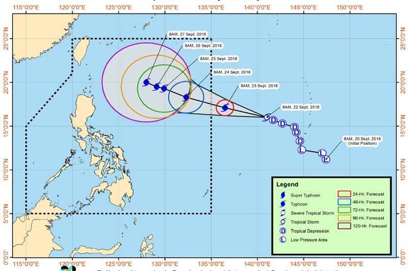
As of 4 p.m., the eye of Typhoon Paeng (international name: Trami) was located 1,290 km east of Tuguegarao City, Cagayan. It is packing maximum winds of 125 kph and gustiness of up to 155 kph, PAGASA said in an advisory at 5 p.m. Sunday.
"Paeng" packs maximum sustained winds of 125 kph near the center and gustiness of up to 155 kph.
The state weather bureau said the typhoon is not likely to make landfall in any part of the country.
Forced evacuations to be enforced in Cordillera
"Paeng" is moving west at 20 kph. It is expected to affect extreme northern Luzon—Batanes and the Babuyan Group of Islands—around Friday, PAGASA said.
It added that there is a possible hoisting of Tropical Cyclone Warning Signals over extreme northern Luzon by Thursday or Friday.
The Office of the Civil Defense in Cordillera Saturday said it would implement forced evacuation in the event of heavy rainfall brought by the incoming typhoon.
“We will strictly implement forced evacuation with the local governments, we have learned our lesson,” it said.
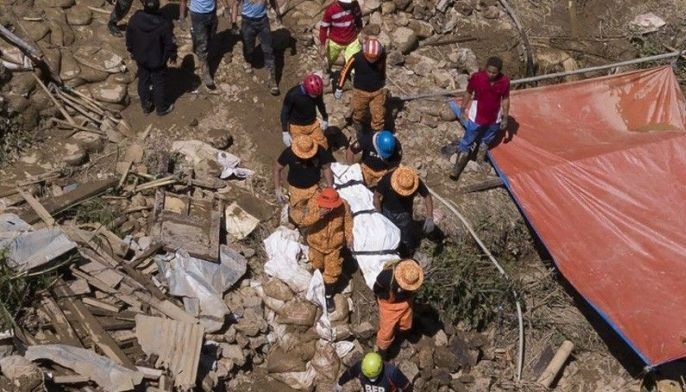
Cordillera was heavily battered by the previous Typhoon Ompong (international name: Mangkhut), which was touted as the strongest typhoon to hit the world this year. Landslides killed at least 60 in the gold mining village of Itogon, Benguet.
Meanwhile, PAGASA said the country is also being affected by the Inter-tropical Convergence Zone. Palawan is expected to have scattered rain showers and thunderstorms while Metro Manila and Luzon are forecast to experience fair weather and occasional rains brought by localized standard storms.
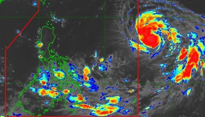
"Trami," the weather disturbance PAGASA is monitoring outside the Philippine area of responsibility, is now a typhoon. It will enter PAR this afternoon and will be assigned the name "Paeng."
State weather bureau PAGASA says Typhoon Paeng is now outside the Philippine Area of Responsibility.
The weather disturbance poses no direct effect in any part of the country. But sea travel remains risky over northern and eastern seaboards of Luzon, PAGASA warns.
Typhoon Paeng was 750 kilometers east of Basco, Batanes early Thursday morning and slowly moving north, PAGASA says in a briefing.
The typhoon, which has veered away from Luzon, has maximum winds of 160 kilometers per hour at the center and gustiness of 195 kph.
The state weather bureau is also keeping an eye on a Low Pressure Area 3,100 km east southeast of Mindanao.
The LPA will very likely develop into a typhoon and enter the Philippine Area of Responsibility by next Monday or Tuesday
As of 3 a.m. Tuesday, the eye of typhoon Paeng was located at 740 kilometers east of Basco, Batanes, with maximum sustained winds of 200 kilometers per hour near the center and gustiness of up to 240 kilometers per hour.
It is expected to move west northwest at 10 kilometers per hour.
PAGASA says the country can expect fair weather despite the typhoon being in the Philippine Area of Responsibility, but localized thunderstorms are expected in the afternoon and evening. No storm warning signals have been raised anywhere in the country.
Typhoon Trami has entered PAR and was named "Paeng," PAGASA says in an advisory at 5 p.m. today.
"Paeng" has no direct effect yet in any part of the country. But it may affect the extreme northern Luzon around Friday, September 28.


- Latest
- Trending