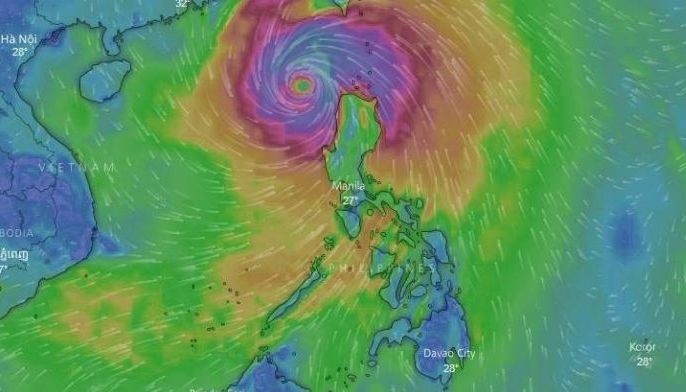
‘Ompong’ weakens anew, to leave PAR Saturday night
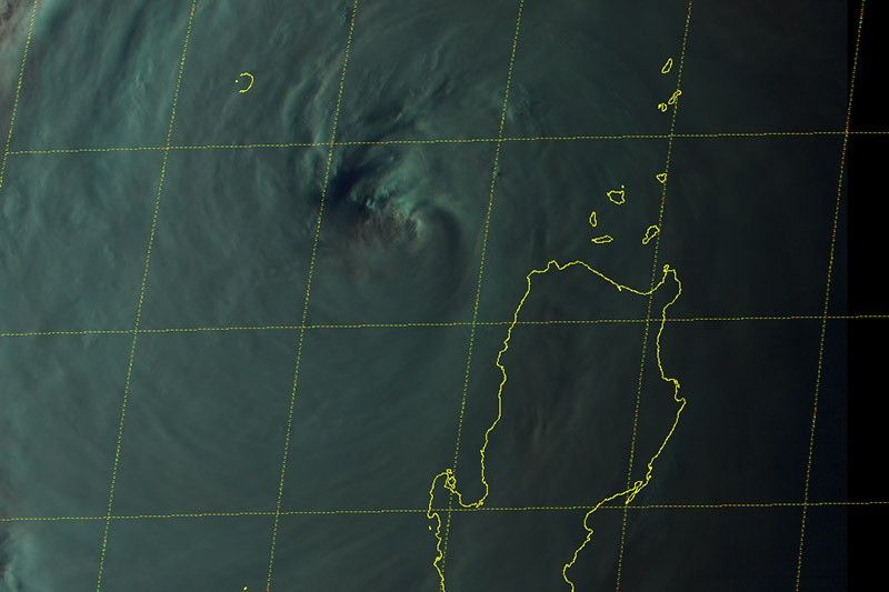
MANILA, Philippines — Typhoon Ompong (international name: Mangkhut) has weakened anew after it slashed through the northern tip of Luzon, state weather bureau PAGASA said.
“Ompong” now packs maximum sustained winds of up to 160 kilometers per hour near the center from the previous 170 kph. Its gustiness also decreased to 195 kph from the previous 260 kph.
As of 4:00 p.m., the eye of the typhoon was located 160 kilometers west northwest of Laoag City, Ilocos Norte.
“Ompong” is expected to leave the Philippine Area of Responsibility between 8 p.m. to 10 p.m. Saturday.
It is heading toward Hong Kong and southern China at a pace of 25 kph.
“Ompong”—the biggest cyclone to hit the Philippines this year—has left at least three casualties so far, authorities said.
The powerful weather disturbance ripped off roofs, uprooted trees, knocked down power and communication lines and triggered floods and landslides in northern and central Luzon.
Over 105,000 people fled their homes, seeking to escape the wrath of the typhoon.
Although “Ompong” weakened, its effects are still threatening areas placed under storm signal warnings.
Signal No. 3 (Winds of 121 to 170 kilometers per hour is expected in at least 18 hours)
- Ilocos Norte
- Ilocos Sur
- La Union
- Abra
- Apayao
- Kalinga
- Mountain Province
- Ifugao
- Benguet
Signal No. 2 (Winds of 61 to 120 kilometers per hour expected in 24 hours)
- Batanes
- Cagayan including Babuyan Group of Islands
- Isabela
- Nueva Vizcaya
- Quirino
- Pangasinan
- Zambales
- Tarlac
- Pampanga
- Bulacan
- Nueva Ecija
- Aurora
Signal No. 1 (Winds of 30 to 60 kilometers per hour)
- Metro Manila
- Bataan
- Rizal
- Cavite
- Batangas
- Laguna
- Lubang Island
- Northern Quezon including Polillo Islands
PAGASA raised an orange warning level alert in Bataan and Bulacan. Residents of these affected areas will experience intense rainfall in the next three hours.
A yellow warning, meanwhile, was raised in Zambales. Heavy rainfall will persist in the area for the next three hours.
Although the state weather bureau lifted storm surge warnings, it advised fisherfolks and those with small sea crafts not to venture out over the seaboards of areas under storm warning signals and the seaboards of Luzon and Visayas.
Moreover, the southwest monsoon boosted by the typhoon will bring gusty winds with occasional moderate to heavy rains over Western Visayas and MIMAROPA.
Residents of Bicol region and eastern and central Visayas will be affected by light to moderate to at times heavy rains.
Filipinos may expect improved weather by Monday, PAGASA said.
Forecast positions
- Sunday afternoon: 770 kilometers west northwest of Laoag City, Ilocos Norte (Outside PAR)
- Monday morning: 1,480 kilomter west northwest of Laoag City, Ilocos Norte (Outside PAR)
— Gaea Katreena Cabico


- Latest
- Trending