PAGASA says potential super typhoon may enter PAR this week
MANILA, Philippines— The state weather bureau on Sunday said a tropical storm that may develop into a super typhoon may enter the Philippine area of responsibility this week.
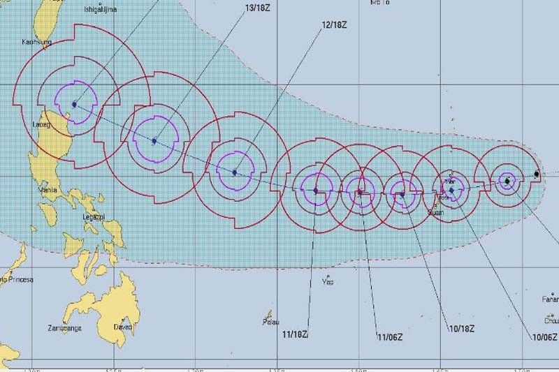
PAGASA weather forecaster Gener Quitlong said Tropical Storm Mangkhut is seen to enter PAR on Wednesday or Thursday and will be assigned the name "Neneng" once it does.
"Baka nga maging super typhoon pa nga po ito. Baka umabot ito kay Jebi... iyong tumama sa Japan, (It may intensify into a super typhoon. It may even be as strong as Jebi… the one that hit Japan," Quitlong was quoted in a radio interview with dzMM.
Mangkhut was located 3,000 kilometers east of northern Luzon on Sunday morning.
Aside from the looming entrance of a potential super typhoon, PAGASA said it is also monitoring two low pressure areas inside PAR.
As of 3 a.m., one of the LPAs was traced at 130 km northwest of Basco, Batanes while the other was located at 815 km east of Hinatuan, Surigao del Sur.
PAGASA weather forecaster Meno Mendoza said these LPAs are affecting some parts of the country including Mindanao, Visayan region and northern Luzon, where rains are expected.
Mendoza said Batanes and Babuyan Islands are forecast to experience scattered rain showers and thunderstorms while Metro Manila and the rest of Luzon will have a fair weather with occasional downpour.


- Latest
- Trending