‘Domeng’ develops into typhoon as it leaves PAR
MANILA, Philippines — The state weather bureau said weather disturbance “Domeng” (international name: Maliksi) has developed into a typhoon as it departed the Philippine Area of Responsibility.
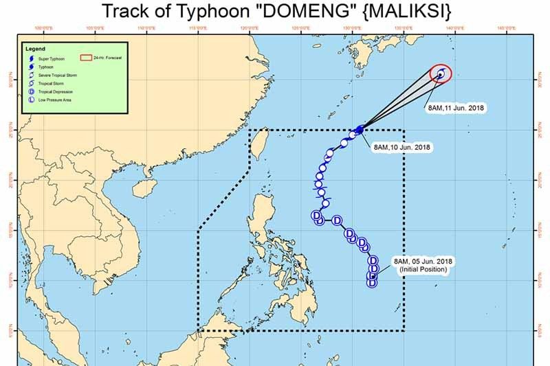
In its severe weather bulletin at 9 a.m., PAGASA said Domeng’s eye was last traced outside PAR at 1,045 kilometer east northeast of Basco, Batanes.
The typhoon has maximum sustained winds of 120 kilometer per hour near the center and gustiness of up to 145 kilometer per hour.
PAGASA reiterated that despite its exit, Domeng still enhanced southwest monsoon or habagat, which will continue to bring rains over some parts of Luzon especially over the western section until early next week.
Domeng is expected to move northeast at 37 kph and remain northeast of Basco, Batanes until Monday.
Due to this, PAGASA said sea travel remains risky around Luzon.
PAGASA said its latest bulletin was the last it would issue for Domeng unless it comes back into the Philippine Area of Responsibility..
“The public is advised to continue monitoring for updates, take appropriate actions against possible flooding and landslides, and coordinate with local disaster risk reduction and management offices,” PAGASA said. —Rosette Adel
Gear up for a rainy weekend.
PAGASA says Tropical Depression Domeng is expected to bring moderate to occasionally heavy rains over Southern Luzon and Western Visayas and scattered rain showers over the rest of Luzon and of Visayas in the next 24 hours.
The tropical depression's eye was last spotted at 470 km east of Casiguran, Aurora. It continues to barrel north at 15 kph.
It packs maximum sustained winds of 60 kph and gustiness of 75 kph.
PAGASA says Tropical Storm Domeng accelerates north northwestward and is now outside the Philippine Area of Responsibility.
The eye was spotted 990 kilometers east northeast of extreme northern Luzon.
Monsoon rains enhanced by Typhoon Domeng (international name: Maliksi), which left the Philippine area of responsibility yesterday, are expected over Bicol, Oriental Mindoro, Marinduque and Romblon.
PAGASA warns against possible flooding or landslides in the said areas.
Meanwhile, the state weather bureau says partly cloudy to cloudy skies with isolated rain showers or thunderstorms will prevail over Northern Samar.
Moderate to strong winds blowing from the southwest will be experienced with moderate to rough seas over Bicol and Northern Samar. Strong to gale winds blowing from the southwest will prevail with rough to very rough seas over Oriental Mindoro, Marinduque and Romblon.
Metro Manila may experience rains until Thursday, PAGASA's three-day forecast shows.
The state weather bureau says Domeng has intensified into a typhoon as it departed the Philippine Area of Responsibility.
The typhoon's center was located at at 1,045 kilometers East Northeast of Basco, Batanes (outside PAR) (25.1°N, 130.8°E).
Domeng is forecasted to move northeast at 37 kilometer per hour.
As of 5 p.m., “Domeng” has intensified into a severe tropical storm with maximum winds of 90 km/h and gustiness of up to 115 km/h.
Flooding in the province of Cavite is “threatening,” the state weather bureau says.
Domeng is expected to leave the Philippine Area of Responsibility on Sunday morning.
PAGASA says Tropical Storm Domeng continues to enhance the southwest monsoon, bringing rains that may also trigger flashfloods and landslides over Luzon and Western Visayas for the next two days.


- Latest
- Trending