'Nona' makes fifth landfall in Oriental Mindoro
MANILA, Philippines (UPDATED 1:21 p.m.) — Typhoon Nona (international name Melor) has made its fifth landfall in Pinamalayan, Oriental Mindoro on Tuesday.
The typhoon made its third landfall in Burias Island around 9:45 p.m. on Monday and its fourth landfall in Banton, Romblon around 5:30 a.m. on Tuesday.
Nona made its fifth landfall over Oriental Mindoro at around 10:30 a.m. on Tuesday. It is expected to leave Mindoro by this afternoon.
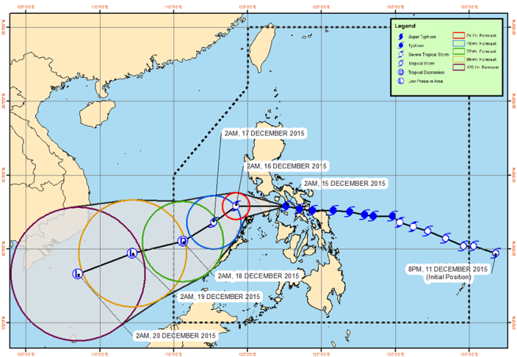
Forecast track of Typhoon Nona as of Tuesday, 7 a.m. PAGASA
At 10 a.m. Nona was located in the vicinity of Pinamalayan, Oriental Mindoro with maximum sustained winds of 140 kilometers per hour (kph) and gusts of up to 170 kph. It is forecasted to move west at 15 kph.
The weather bureau said that the typhoon is expected to weaken due to interaction in landmass and with the presence of cold winds brought by the northeast monsoon.
Public storm warning signals are still raised over areas in southern Luzon and the Visayas.
Signal No. 3
- Calamian Group of Islands
- Mindoro Provinces including Lubang Island
Signal No. 2
- Marinduque
- Batangas
- Romblon
Signal No. 1
- Metro Manila
- Bataan
- Bulacan
- Cavite
- Laguna
- Rizal
- Quezon
- Burias Island
- Northern Palawan
- Aklan
- Antique
LIVE updates: Tropical cyclone 'Nona'
The typhoon is expected to bring heavy to at times intense rainfall within the 250-kilometer diameter of the typhoon.
PAGASA also warned against flash floods and landslides over the areas under signals no. 2 and 3, while storm surges of up to 3 meters are possible.
AccuWeather Meteorologist Adam Douty said "Nona" will continue to weaken as it crosses the central areas of the Philippines into Tuesday, but its damaging wind gusts at over 130 kph will target the rest of southern Luzon.
"[Nona] is a very compact typhoon, so that will prevent its most devastating impacts from extending too far from its center," Douty said in a report Tuesday.
He said Metro Manila is likely to be affected by heavy rainfall, even as strong winds are expected to bypass the country's capital.
The weather agency says the cyclone system is forecasted to be at 205 kilometers northwest of San Jose, Occidental Mindoro by Wednesday morning, and will continue to head 270 kilometers west of Coron, Palawan on Thursday.
Nona is expected to weaken into a tropical storm by Wednesday morning exit the Philippine area of responsibility (PAR) by Friday as a low pressure area.
Meawhile, PAGASA is monitoring a low pressure area outside the PAR. It may strengthen into a tropical depression by Friday. — Patricia Lourdes Viray


- Latest
- Trending