QuintaPH
Typhoon Quinta is forecast to exit the Philippine Area of Responsibility on Tuesday morning and is seen to intensfy over the West Philippine Sea and reach peak intensity in the next 24 hours, PAGASA says in its early morning bulletin on Tuesday.
The typhoon is expected to bring moderate to heavy rains over Western Visayas, Occidental Mindoro, Palawan including Calamian, Cuyo, and Kalayaan Islands, Aurora, Isabela, Cagayan.
Light to moderate with at times heavy rains over Zamboanga Peninsula, Bangsamoro, Northern Mindanao, Caraga, and the rest of Luzon and Visayas, PAGASA says.
Typhoon Quinta continues to intensify as it moves away from the Philippines, state weather bureau PAGASA says Monday night.
The typhoon is forecast to exit the Philippine Area of Responsibility Tuesday morning and reach its peak intensity within 24 hours.
At 10 p.m., Quinta was located 420 km west of Calapan City, Oriental Mindoro with maximum winds of 140 kph and gusts of 170 kph. It is moving westward at 25 kph.
Signal No. 1 is still hoisted over Lubang Island, Calamian Islands and Kalayaan Islands.
Typhoon Quinta slightly intensifies as it moves towards the western boundary of the West Philippine Sea.
It is forecast to reach its peak intensity in the next 24 hours but would exit the country Wednesday morning, state weather bureau PAGASA says.
At 4 p.m., Quinta was located 310 km west of Calapan City, Oriental Mindoro with maximum sustained winds of 130 kph near the center and gustiness of up to 160 kph.
'Quinta' was 125 kilometers north of Coron, Palawan as of 10 a.m., PAGASA says, or 120 km west southwest of Calapan City, Mindoro.
The typhoon is moving west at 25 km/h and has maximum sustained winds of 125 km/h near the center and gustiness of up to 150 km/h.
Tropical Cyclone Wind Signal No. 3:
Northwestern portion of Occidental Mindoro (Abra de Ilog, Mamburao, Paluan), including Lubang Island
TCWS No. 2 :
Oriental Mindoro
The rest of Occidental Mindoro
Calamian Islands
Batangas
Visayas
Extreme northern portion of Antique (Caluya)
TCWS No. 1:
- Southern portion of Zambales (San Antonio, Castillejos, Subic, Olongapo City)
- Bataan
- Southwestern portion of Pampanga (Floridablanca, Lubao, Sasmuan, Masantol)
- Southwestern portion of Bulacan (Hagonoy, Paombong, Malolos City, Bulacan, Obando, Meycauayan City)
- Metro Manila
- Rizal
- Cavite
- Laguna
- Quezon including Polillo Islands
- Marinduque
- Romblon
- Northern portion of Palawan (El Nido, Taytay), including Cuyo Islands
Visayas
- Aklan and the rest of the northern portion of Antique (Laua-An, Barbaza, Tibiao, Culasi, Sebaste, Pandan, Libertad)
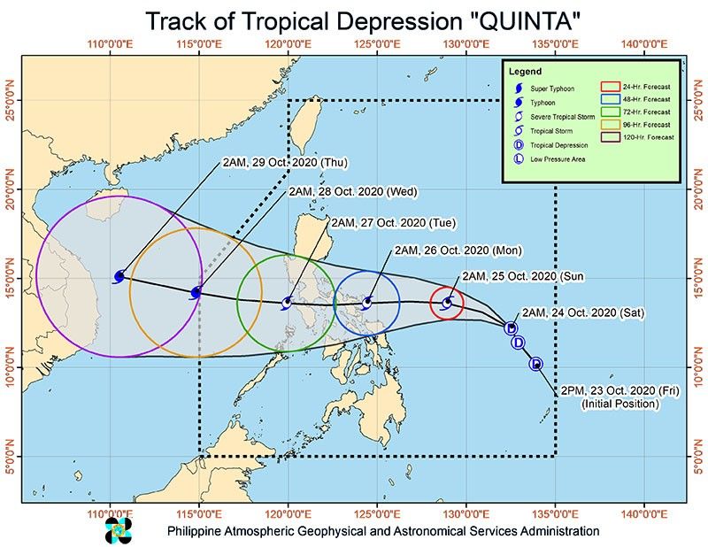
'Quinta' made a fifth landfall over Pola, Oriental Mindoro early Monday morning as it traverses the island and is expected to emerge over the West Philippine Sea.
As of 4 a.m., 'Quinta' was in the vicinity of Socorro, Oriental Mindoro as of 4 a.m., according to an early morning PAGASA bulletin. The typhoon is moving west at 25 kilometers per hour and has maximum sustained winds of 125 km/h near the center and gustiness of up to 180 km/h.
Tropical Cyclone Wind Signal No. 3 is up over the following areas:
- The southern portion of Quezon (Mulanay, San Francisco, Catanauan, General Luna, Macalelon, Pitogo, Unisan, Agdangan, Padre Burgos, Pagbilao, Lucena City, Sariaya, Candelaria, Tiaong, San Antonio, Dolores, Tayabas City)
- Southern portion of Batangas (Lian, Tuy, San Juan, Rosario, Padre Garcia, Lipa City, Cuenca, San Jose, Ibaan, Taysan, Lobo, Batangas City, Mabini, Tingloy, San Pascual, Bauan, Alitagtag, San Luis, Taal, Santa Teresita, Calatagan, Balayan, Calaca, Lemery, Agoncillo, San Nicolas, Mataas Na Kahoy)
- Northern portion of Romblon (Concepcion, Banton, Corcuera, Romblon, San Agustin, Calatrava, San Andres, Odiongan, Santa Maria)
- Marinduque
- Northern and central portion of Oriental Mindoro (Oriental Mindoro (Mansalay, Roxas, Bongabong, Bansud, Gloria, Pinamalayan, Pola, Socorro, Victoria, Naujan, Calapan City, Baco, San Teodoro, Puerto Galera)
- Northern and central portion of Occidental Mindoro (San Jose, Rizal, Calintaan, Sablayan, Santa Cruz, Mamburao, Paluan, Abra de Ilog) including Lubang Island
Tropical Cyclone Wind Signal No. 2 areas:
- Camarines Norte
- Western portion of Camarines Sur (Siruma, Tinambac, Calabanga, Naga City, Pili, Bula, Balatan, Minalabac, Milaor, Bombon, Magarao, Canaman, Camaligan, Gainza, San Fernando, Pasacao, Pamplona, Cabusao, Libmanan, Sipocot, Lupi, Ragay, Del Gallego)
- Burias Island
- Rest of Quezon, including Polillo Islands
- Laguna
- Rest of Batangas
- Cavite, Rizal
- Metro Manila
- Southern portion of Bulacan (Norzagaray, Angat, San Rafael, Baliuag, Pulilan, Calumpit, Hagonoy, Paombong, Malolos City, Plaridel, Bustos, San Jose del Monte City, Santa Maria, Pandi, Guiguinto, Balagtas, Bulacan, Bocaue, Meycauayan City, Obando, Marilao)
- Southern portion of Pampanga (Lubao, Sasmuan, Macabebe, Masantol, Minalin, Apalit), Bataan
- Rest of Romblon
- Rest of Oriental Mindoro
- Rest of Occidental Mindoro, and Calamian Islands
Visayas
- Extreme northern portion of Antique (Caluya)
Tropical Cyclone Wind Signal No. 1 areas:
- Catanduanes
- Rest of Camarines Sur
- Albay
- Western portion of Sorsogon (Donsol, Pilar, Castilla, Sorsogon City, Casiguran, Juban, Magallanes, Bulan, Irosin)
- Northern portion of mainland Masbate (Uson, Mobo, Masbate City, Baleno, Aroroy, Balud, Mandaon, Milagros) including Ticao Island
- Southern portion of Aurora (Dingalan, San Luis)
- Southern portion of Nueva Ecija (Gabaldon, Laur, Palayan City, General Tinio, Cabanatuan City, Aliaga, Zaragoza, Jaen, San Antonio, Santa Rosa, Peñaranda, Gapan City, San Leonardo, San Isidro, Cabiao)
- Southern portion of Tarlac (La Paz, Tarlac City, San Jose, Concepcion, Capas, Bamban)
- Rest of Bulacan
- Rest of Pampanga
- Central and southern portion of Zambales (Iba, Botolan, Cabangan, San Felipe, San Narciso, San Antonio, San Marcelino, Castillejos, Subic, Olongapo City)
- Northern portion of Palawan (El Nido, Taytay) including Cuyo Islands
Visayas
- The rest of the northern portion of Antique (Laua-An, Barbaza, Tibiao, Culasi, Sebaste, Pandan, Libertad)
- Aklan
- Capiz
- Northern portion of Iloilo (Lemery, Sara, San Dionisio, Batad, Estancia, Carles, Balasan)
"Quinta" has intensified into a typhoon as it moves westward before likely makily landfall over the eastern coast of Camarines Sur - northeastern coast of Albay Sunday night.
"After crossing the Philippine archipelago, this tropical cyclone will continue intensifying over the West Philippine Sea," state weather bureau PAGASA says.
At 4 p.m., the typhoon was located 70 km east northeast of Legazpi City, Albay with winds of 130 kph near the center and gustiness of up to 160 kph. It is moving west at 25 kph.
Typhoon Quinta will bring stormy weather to Bicol Region, CALABARZON, Marinduque, Romblon, Mindoro Provinces and Northern Samar in the next 24 hours, PAGASA says.
Metro Manila, Central Luzon, Eastern Samar, Samar, Biliran, Iloilo, Capiz, Aklan, Antique, and Calamian Islands will also experience rains with gusty winds.
A 3 p.m., the typhoon was located 35 km southeast of Virac, Catanduanes or 90 km east northeast of Legaspi City, Albay with maximum sustained winds of 130 kph near the center and gustiness up to 160 kph. It is moving Westward at 25 kph.
24-HOUR PUBLIC WEATHER FORECAST Issued at 4:00 PM Sunday, 25 October 2020 SYNOPSIS: At 3:00 PM today, the eye of...
Posted by Dost_pagasa on Sunday, 25 October 2020
Tropical storm Quinta continues to intensify as it moves closer to the Catanduanes-Albay area.
The weather disturbance remains likely to make landfall and is likely to exit the Philippine Area of Responsibility Tuesday afternoon.
At 1 p.m., Quinta was located 95 kph east of Virac, Catanduanes with winds of 110 kph and gusts of up to 135 kph.
"Quinta" has intensified into a severe tropical storm as it moves westward before making landfall over Bicol region, state weather bureau PAGASA says.
It is forecast to further intensify into a typhoon by Tuesday as it moves over the West Philippine Sea.
At 10 a.m., Quinta was located 180 km east of Virac, Catanduanes with winds of 95 kph and gusts of up to 115 kph. It is moving westward at 25 kph.
Tropical Storm "Quinta " continues to move generally westward until its landfall over the Catanduanes-Albay-Sorsogon area Sunday afternoon or evening.
At 7 a.m., Quinta was located 265 km east of Virac, Catanduanes with maximum sustained winds of 75 kph and gusts of up to 90 kph. It is moving westward at 20 kph.
PAGASA reports that Tropical Depression Quinta has maintained its strength while moving west-northwest towards Bicol Region.
The eye of "Quinta" was spotted at 610 kilometers east of Juban, Sorsogon.
It is moving west-northwest at 20 kilometers per hour. "Quinta" has maximum sustained winds of 55 kph near the center and gustiness of up to 70 kph.
PAGASA says Tropical Depression Quinta slightly accelerates while moving west-northwest over the Philippine Sea.
Based on its 11 a.m. advisory, "Quinta" was located at 660 kilomeres east of Catarman, northern Samar or 730 km east of Juban, Sorsogon.
It has maximum sustained winds of 55 kilometers per hour, near the center and gustiness of up to 70 kph. "Quinta" moving west northwest at 30 kph.
Follow this thread for updates on tropical cyclone Quinta.


- Latest
- Trending