#OmpongPH
The Department of the Interior and Local Government tallies 66 dead, 62 missing in wake of Typhoon Ompong, ONE News reports.
DILG says 66 were already reported dead and 62 are missing due to the onslaught of Typhoon #OmpongPH. | via @News5AKSYON / @ryanangnews5 pic.twitter.com/AqHV4KfHCd
— ONE News PH (@onenewsph) September 18, 2018
The department says it will also look into potential lapses in local governments' disaster preparations.
The United Church of Christ in the Philippines clarifies Tuesday that a church reported to have collapsed in a landslide in Itogon, Benguet was an old bunkhouse that was being used as a place of worship by United Church Fellowship (Pentecostal Group).
The casualty figure on Monday was at 56 dead but the figure is expected to rise, with around 40 to 50 people believed to still be buried in the mud as search and retrieval operations continue.
Presidential spokesman Harry Roque, who said he is a member of UCCP, on Monday played down President Rodrgo Duterte's remark over the weekend that the "church" would not have collapsed if people had replaced the priest there. He also said priests are stupid.
"Ang tingin ko naman po, hindi naman po seryoso ang presidente. Let's not take his words always literally," Roque said.
Benguet was one of the areas hardest hit by Typhoon Ompong (Mangkhut) over the weekend.
Philippine and Chinese authorities say the death toll from a typhoon has risen to at least 69 with dozens missing.
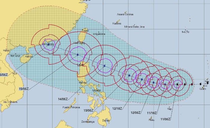
Mangkhut weakened to a tropical storm Monday morning as it moved deeper into southern China, where rain and strong winds were expected to continue through Tuesday.
A Philippine national police report said the death toll as of Monday midday was 65, with 43 people missing and 64 injured. Chinese authorities reported four deaths from falling trees and building materials in Guangdong, China's manufacturing hub.
Many of the missing in the Philippines are gold miners and their families feared buried in a landslide after seeking shelter in a bunkhouse-turned-chapel in a village in Benguet province.
Mangkhut battered the northern Philippines on Saturday before slamming into southern China on Sunday. It was the most powerful typhoon to hit Hong Kong since 1979, packing winds of 195 kilometers per hour (121 mph). — AP
Mangkhut has weakened from a typhoon to a tropical storm as it moves deeper into China.
The storm was still affecting southern China's coast and the provinces of Guangdong, Guangxi and Hainan on Monday morning and rain and strong winds were expected to continue through Tuesday.
Hong Kong residents were being told to stay away from the coastline and be on alert for occasional gales. Bus, ferry and rail services were suspended and almost 900 flights were canceled at the city's airport, one of the world's busiest. The South China Morning Post said Hong Kong's hospitals had to use backup power due to outages caused by the storm.
Mangkhut earlier lashed the Philippines, sparking landslides and building collapses that killed at least 64 people. At least two deaths have been reported in China. As of Monday morning Mangkhut was on track to pass over the Guangxi regional capital of Nanning.
The Hong Kong Observatory reported Mangkhut was the most powerful cyclone to hit the city since 1979, packing maximum sustained gusts of 195 kilometers per hour (121 mph). — AP
Australia is providing A$800,000 (P30.9 million) worth of humanitarian supplies to the Philippines in the aftermath of Typhoon Ompong. This includes sleeping mats, blankets and hygiene and shelter kits for up to 25,000 people in the most affected areas.
These supplies are being distributed by the Philippine Red Cross.
Australia also deployed humanitarian experts to the Philippines.
"Our Embassy is coordinating closely with Philippine authorities and our international partners... We stand ready to provide further assistance, if requested by the Philippine Government," the Australian government says.
President Duterte will visit today Cagayan, its capital Tuguegarao City and Ilocos Norte, areas lashed by "Ompong" the hardest, to personally get an assessment of the damage caused by the typhoon in northern Luzon, Malacañang announces.
PAGASA says the southwest monsoon or "habagat" enhanced by "Ompong" will bring occasional gusty winds and scattered light to moderate to at times heavy rains over Western Visayas, Mimaropa, Ilocos Region, Batangas, Bataan and Zambales.
Although outside the typhoon is now outside the Philippine area of responsibility, the state weather bureau is advising fisherfolk and those with small seacraft not to venture out over the northern and western seaboards of Luzon.
Typhoon Ompong continues to barrel towards southern China after having left the Philippine area of responsibility at 9 p.m. on Saturday.
PAGASA issued its 23rd severe weather bulletin on Ompong at 5 a.m. today, its final one on the typhoon. All tropical cyclone warning signals are now lifted.
At 4 a.m. today, the eye of "Ompong" was located at 570 km west of Basco, Batanes. It packs maximum sustained winds of 145 kph near the center and gustiness of up to 180 kph.
As of 6 p.m. Saturday, the eye of typhoon Ompong was spotted 215 kilometers west northwest of Laoag City, Ilocos Norte, PAGASA says.
“Ompong” is expected to leave the Philippine area of responsibility between 8 p.m. to 10 p.m. Saturday.
Typhoon Ompong weakens slightly as it continues to move in a west northwestward direction.
At 4 p.m. Saturday, the eye of the typhoon was at 160 kilometers west northwest of Laoag City, Ilocos Norte, moving west northwest at 25 kilometers per hour.
"Ompong" packs maximum sustained winds of 160 kilometers per hour near the center and gustiness of up to 195 kph.
Two women were killed Saturday in a landslide set off by Super Typhoon Mangkhut, Philippine police say.
Officers in the city of Baguio recovered the women's bodies from the soil and rubble after a hillside collapsed from the typhoon's heavy rains, says police Superintendent Pilita Tacio. — AFP
Typhoon Ompong maintains its strength as it moves in a west northwestward direction.
As of 1 p.m. Saturday, the eye of "Ompong" was spotted at 85 kilometers west of Laoag City, Ilocos Norte; packing winds of 170 kilometers per hour near the center and gustiness of up to 260 kph.
It is forecast to move west-northwest at 25 kph.
"Ompong" continues to weaken and is now off the coast of Laoag City, Ilocos Norte, PAGASA says.
At 10 a.m. Saturday, the eye of the "Ompong" was located at 30 kilometers west of Laoag City, Ilocos Norte and packs maximum sustained winds of up to 170 kilometers per hour with gusts of up to 260 kilometers per hour.
The typhoon is likely to move west at 25 kilometers per hour.
Tropical cyclone warning signals are now lowered.
The Hawaii-based Joint Typhoon Warning Center has downgraded Mangkhut (local name Ompong) from a super typhoon to an equivalent of a category 4 hurricane, after making landfall in the northeastern Philippines before dawn Saturday.
The Philippine government has reported no casualties so far as the typhoon continued to pummel Luzon with heavy rains and gusts. Transportation has ground to a halt as many roads are flooded and airports closed.
According to JTWC, Mangkhut is packing maximum sustained winds of 115 knots, or 212 kilometers (130 miles) per hour. The Philippine weather agency has slightly lower numbers. — AP
Typhoon Ompong has slightly weakened while heading towards Ilocos Norte hours after it made a landfall over Baggao, Cagayan.
In a press briefing, PAGASA said “Ompong” was last located in the vicinity of Kagubao, Apayao, moving west at 30 kilometers per hour.
It packs maximum sustained winds of 185 kilometers per hour near the center and gustiness of up to 305 kilometers per hour.
Typhoon Ompong is now heading toward Apayao and Ilocos Norte after battering northern Isabela and Cagayan, where it made a landfall early Saturday morning.
The most powerful cyclone of the year so far barely lost its intensity, as it still packed 200 kph winds near the center after hitting land. It has gustiness of up to 330 kph.
Still under tropical cyclone warning signal number 4 are Cagayan, northern Isabela, Apayao, Kalinga and Babuyan Islands.
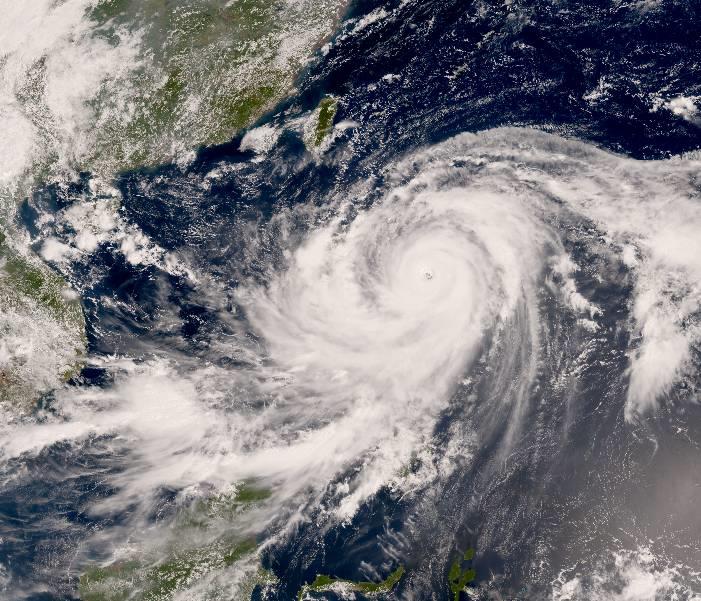
Typhoon "Ompong" (international name: Mangkhut) slammed into the Philippines largest island of Luzon with its 205 kph winds Friday evening.
State weather agency PAGASA said late Friday evening that the eye of the 900 km-wide Ompong is expected to make landfall in Cagayan between 1 a.m. to 3 a.m. after several days at full strength while slowly moving closer to the Philippines.
Ompong continues to pack maximum winds of up to 205 kph and gustiness of up to 255 kph as it continues moving at 30 kph west northwest, PAGASA said.
Cagayan and neighboring areas of Ilocos Norte, northern Isabela, Apayao, Abra, Kalinga, Babuyan Group of Island have all been placed under Signal No. 4 as of 10 p.m.
Signal No. 4 was raised over Cagayan and northen Isabela as Typhoon Ompong (international name Mangkhut) continues to threaten northern Luzon, PAGASA says.
"Ompong" has little chance of reaching Signal No. 5, the state weather bureau adds.
PAGASA says Ompong has maintained its strength since early this morning as it heads for the Cagayan-Isabela area where it is likely to make a landfall.
Its eye was located 540 kilometers east of Baler, Aurora as of 10 a.m. with packing maximum sustained winds of 205 kilometers per hour and gusts of up to 255 kph.
Ompong also continues to be a slow-moving cyclone, tracking a northwest direction at 20 kph.
Tropical Cyclone Warning Signal No. 3 has been raised over Northern Aurora, Isabela and Cagayan, PAGASA says in its 8 a.m. briefing.
That means a tropical cyclone will affect these areas and winds of 100 kph up to 185 kph may be expected within at least 18 hours.
PAGASA warns that TCWS No. 3 means the typhoon is dangerous to affected communities and that people should seek shelter in strong buildings. Low-lying areas and those near coasts and river banks should be evacuated.
"Watch out for the passage of the 'eye' of the typhoon indicated by a sudden occurrence of fair weather immediately after very bad weather with very strong winds coming generally from the north," PAGASA also says.
It says people in affected communities should not venture away from safe shelter as worse weather will resume within one or two hours.
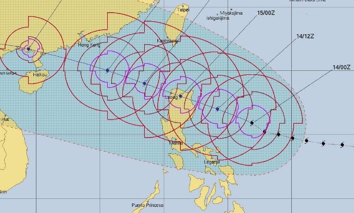
Forecast position:
- 24 Hour(Tomorrow morning): In the vicinity of Peñablanca, Cagayan(17.6°N, 122.2°E)
- 48 Hour(Sunday morning):430 km West Northwest of Laoag City, Ilocos Norte (OUTSIDE PAR)(19.3°N, 116.7°E)
- 72 Hour(Monday morning): 1,205 km West of Basco, Batanes (OUTSIDE PAR)(21.2°N, 110.4°E)
- 96 Hour(Tuesday morning):1,800 km West of Basco, Batanes (OUTSIDE PAR)(21.8°N, 104.7°E)
PAGASA has raised Tropical Cyclone Warning Signal No. 3 over Isabela province as Typhoon Ompong maintains strength.
Ompong, which is expected to make landfall in the Cagayan-Isabela area, has maximum sustained winds of 205 kph near the center and gustiness of up to 255 kph.
It was 655 km east of Infanta, Quezon as of the 5 a.m update. The typhoon, which is said to be the strongest to hit the Philippines this year, was moving west northwest at 20 kph early Friday morning.
Storm warning signals have also been raised over other areas in Luzon and the Visayas
Tropical Cyclone Warning Signal No. 2
- Batanes
- Cagayan, including Babuyan group of Islands
- Ilocos Norte
- Ilocos Sur
- Apayao
- Abra
- Kalinga
- Mountain Province
- Ifugao
- La Union
- Benguet
- Nueva Vizcaya
- Quirino
- Pangasinan
- Nueva Ecija
- Aurora
- Tarlac
Tropical Cyclone Warning Signal No. 1
- Pampanga
- Bataan
- Zambales
- Bulacan
- Rizal
- Metro Manila
- Cavite
- Batangas
- Laguna
- Quezon, including Polillo Island
- Northern Oriental Mindoro
- Masbate
- Marinduque
- Camarines Norte
- Camarines Sur
- Catanduanes
- Albay
- Sorsogon
- Burias and Ticao Island
- Northern Samar
PAGASA has placed more areas under Signal No. 1 in its 11 a.m. severe weather bulletin:
- Batanes
- Cagayan including Babuyan Group of Islands
- Apayao
- Abra
- Kalinga
- Mountain Province
- Ifugao
- Isabela
- Benguet
- Quirino
- Nueva Vizcaya
- Aurora
- Nueva Ecija
- Bulacan
- Rizal
- Laguna
- Quezon including Polillo Island
- Camarines Norte
- Camarines Sur
- Catanduanes
- Albay
- Sorsogon
- Burias Island
- Ticao Island
Fourteen areas are placed under Signal No. 1 by PAGASA, according to its latest bulletin at 5 a.m. today.
These are:
- Cagayan
- Isabela
- Kalinga
- Mt. Province
- Ifugao
- Nueva Vizcaya
- Quirino, Aurora
- Quezon including Polillo Island
- Camarines Norte
- Camarines Sur
- Albay
- Sorsogon
- Catanduanes
- Burias and Ticao Islands Northern Samar
"Ompong" has maintained its strength with maximum sustained winds of up to 205 kph near the center and gustiness of up to 255 kph.
Typhoon Mangkhut has entered the Philippine area of responsibility as of 3 p.m. and was assigned the name "Ompong."
The Philippine Coast Guard has cancelled sea trips between Cebu and Bohol from Thursday noon in anticipation of bad weather, The Freeman reports from Cebu.
PAGASA sticks to its earlier forecast and says Typhoon Mangkhut likely to enter PAR by this afternoon.
It is expected to reach a peak intensity of around 220-270 kph, the bureau said in its 11 a.m. briefing. This range means that it is likely to reach the super typhoon category by PAGASA's own definition.
The bureau's meteorologist says the effects of the typhoon will be heavily felt by Friday in Luzon, including Metro Manila. It is likely to bring heavy rains.
Super Typhoon Ompong continues its slow 25.9-kilometer per hour track toward the Philippine area of responsibility.
Its intensity, however, has slightly sped up since last night. It now has maximum sustained winds of 259 kph and gusts of 314 kph, according to the US Navy's Joint Typhoon Warning Center.
The typhoon is expected to enter the Philippine area of responsibility later today, and will likely prompt local weather bureau PAGASA to upgrade its status to super typhoon if its winds exceed 220 kph by its own estimate.
Classes have been suspended in Mexico, Pampanga (all levels) and in Bauang, La Union (afternoon classes, all levels) in anticipation of bad weather brought by super typhoon Mangkhut, which may enter the Philippine Area of Responsibility on Wednesday.
Once it enters the PAR, it will be called Ompong.
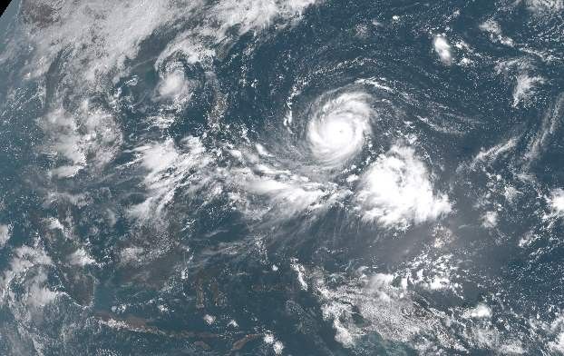
The US Navy's weather bureau upgrades cyclone Mangkhut to super typhoon category as of 5:45 p.m. ahead of the howler's entrance to the Philippine area of responsibility.
The Hawaii-based Joint Typhoon Warning Center estimates that Super Typhoon Mangkhut packs maximum sustained winds of 135 knots or 250 kilometers per hour.
It also has gusts of up to 165 knots or 135 kph as it tracks northwestward at a slow pace of 27 kph.
Super typhoons are also categorized by local state weather bureau PAGASA as cyclones with winds of more than 220 kph. As of posting time, PAGASA is yet to upgrade the typhoon's status.
It will be renamed Ompong once inside the Philippine area of responsibility.
As Tropical Depression Neneng steps out the northwestern boundary of the Philippine area of responsibility, Typhoon Mangkhut continues to approach from the Pacific Ocean. Mangkhut, which will be named "Ompong" once inside PAR this week, was located 1,820 kilometers east of Southern Luzon with winds of up to 160 kilometers per hour and gusts of up to 195 kph.
State weather specialist Chris Perez says Mangkhut is moving west at a speed of 30 kph. It is expected to be in the vicinity of the northernmost areas of the country by the weekend.
Perez says a cyclone warning signal is likely to be raised as early as Thursday, September 13 over the Cagayan Valley region.
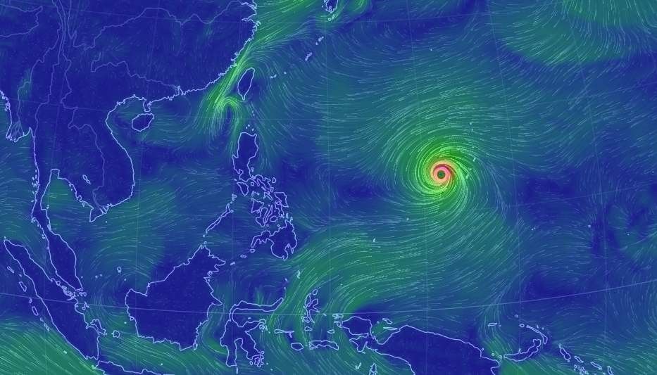
Typhoon Mangkhut is feared to gain strength as it approaches the Philippine area of responsibility. The tropical cyclone will be named "Ompong" once within the country's vicinity.
The United States Navy's Joint Typhoon Warning Center records that "Mangkhut" has maximum sustained winds of 80 knots or 148 kilometers per hour and gusts of up to 185 kilometers per hour as of Monday morning.
Forecast track of the cyclone shows that it is heading toward the northernmost tip of the country's water off northern Luzon by Friday.


- Latest
- Trending