


Cebu braces for tropical storm ‘Auring’
CEBU, Philippines — Cebu province is preparing for the possible effects of tropical storm Auring that is expected to hit Cebu this weekend.
Neil Sanchez, Provincial Risk Reduction and Management Office (PDRRMO) chief, said Auring, the first tropical cyclone to enter the country this year, is likely to affect the northern part of Cebu, bringing heavy rains and gusty conditions.
Cebu’s disaster council, which is composed of PDRRMO and other government agencies, convened yesterday for a pre-disaster risk assessment.
As Cebu braces for Auring, the province is placed today on "blue alert" for the possible onslaught of Auring. Blue alert means disaster officials and staff, and equipment are on standby to ensure that there will be enough manpower and equipment in case of an emergency.
Disaster personnel in towns and cities in Cebu were already directed to identify and activate evacuation centers.
Sanchez said social distancing in evacuation centers would really be a challenge.
"Let’s be realistic about it. Social distancing in evacuation centers will be hard to implement. But what we can do is to implement at least the minimum health standards like regular washing of hands and the wearing of face masks,” he said.
He also urged residents living in danger zones to voluntarily evacuate.
“Our counterparts in LGUs are asked to implement preemptive evacuation. Always remember evacuation is better than rescue,” he said.
Forecast
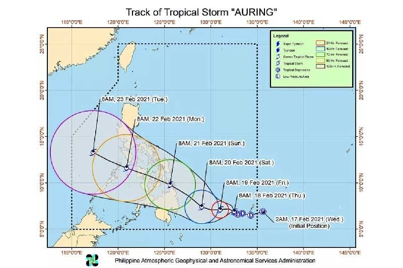
Auring intensified into a tropical storm as of 8 a.m. yesterday ahead of its expected landfall over the Caraga region over the weekend.
State weather bureau PAGASA said Auring is moving slowly northwestward over the Philippine Sea. It now packs winds with speeds of 65 kilometers per hour (kph) with gustiness reaching up to 80 kph.
PAGASA-Visayas weather specialist Jhomer Eclarino said Auring is heading toward central and northern Cebu based on the available meteorological data.
He said Auring will most likely make landfall in central or northern Cebu Sunday or Monday morning.
Signal Number 1 may be hoisted over Cebu later this afternoon.
Tropical Cyclone Wind Signal (TCWS) Number 2 may also be hoisted over the northern part of Negros provinces, Panay Island, and southern Leyte over the weekend.
As of yesterday’s forecast, no locality is currently under TCWS #1. However, in anticipation of the arrival of strong breeze to near-gale conditions due to Auring, TCWS #1 may be raised over several provinces of Caraga and Davao Region as early as today which may result in disruption of maritime activities.
In the next 24 hours, PAGASA said, rough to very rough seas (2.8 to 5.0 m) will be experienced over the seaboards of northern Luzon and the eastern seaboards of central and southern Luzon, Visayas, and Mindanao due to the surge of the northeast monsoon and Auring.
Moderate to rough seas (1.2 to 3.1 m) will be experienced over the rest of the seaboards of the country.
“Sea travel is risky over these areas, especially for mariners of small seacrafts. Mariners of small seacrafts are advised to take precautionary measures when venturing out to sea. Inexperienced mariners should avoid navigating in these conditions,” the weather bureau said. — Mitchelle L. Palaubsanon, KQD (FREEMAN)


- Latest

