Cebu braces for Typhoon ‘Rolly’
CEBU, Philippines — Local authorities are bracing for the possible effects of Typhoon Rolly to Cebu.
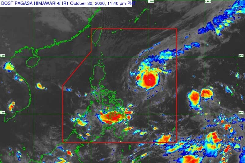
Rolly entered the Philippine Area of Responsibility (PAR) at 5:30 p.m. Thursday.
Cebu City Police (CCPO) and Cebu City Disaster Risk Reduction Management Office (CCDRRMO) are monitoring hazard prone areas, especially residential sites near rivers and other waterways.
Police Colonel Josefino Ligan, CCPO director, said CCPO equipment, vehicles and personnel are on standby ready for deployment if the need arises.
CCPO station commanders are also directed to delegate teams to monitor areas that are prone to landslide and flood and other vulnerable areas, he said.
"Specifically Guadalupe and Talamban areas,” he said.
He said CCPO is also coordinating with barangay captains in the landslide-prone upland villages.
“Our objective is to get timely reports from the grassroots for a corresponding response,” he said.
As for the informal settlers living near creeks, rivers and bridges, he said, they will be advised to vacate if the weather worsens.
CCDRRMO head Ramil Ayuman said barangays in the city have been alerted of Rolly’s possible effects, especially that Visayas is expected to experience rains.
Ayuman said that even if the typhoon will not directly hit Cebu City, they are still preparing for the possible effects of the typhoon such as strong winds and occasional heavy rains.
Yesterday, CCDRMO has called an emergency formation with different emergency response agencies.
Emergency response agencies present during the formation were Cebu City Fire office, Coast Guard Cebu Station, PNP City Mobile Force Company, Barangay fire volunteers of Cebu City, Emergency Rescue Unit Foundation, Philippine Red Cross and AFP 53rd Engineer Brigade.
On the other hand, the Cebu Provincial Disaster Risk Reduction and Management Office (PDRRMO) already sent an advisory to Local Disaster Risks Reduction and Management Office (LDRRMOs) for the monitoring of their risk areas and conduct pre-emptive measures when the need arises.
"As early as yesterday (Thursday), nag-send out naman ta'g advisory sa atong LDRRMOs for the monitoring of their risk areas and as much as possible kung mahimo, mo conduct og pre-emptive measures. Like for example, if the need arises that they need to evacuate their constituents nga affected sa pinisik ni Rolly, then they'll have to do it, they will not wait for the weather to intensify," said PDRRMO head Neil Sanchez.
Sanchez said they also coordinated with the Cebu Provincial Police Office (CPPO) and Task Group Cebu of the third infantry division for the deployments for their assets.
The PDRRMO has two teams on standby for emergency response.
Status
Typhoon “Rolly” continued to intensify ahead of its expected landfall over the Aurora-Quezon area on Sunday evening or early Monday morning, PAGASA said in its 11 a.m. bulletin yesterday.
According to the state weather bureau, "Rolly," which was last spotted 1,100 kilometers east of Central Luzon, packs winds of 165 kilometers per hour near the center and gusts of up to 205 kilometers per hour (kph).
No storm signal warning is up yet, but PAGASA said it may hoist Signal Number 1 over several provinces in the Bicol region.
It also warned that it is likely that Signal Number 3 or 4 would be raised throughout the passage of the typhoon as it is expected to continue intensifying prior to landfall, when its winds would peak at 175 to 185 kph.
The US Navy’s Joint Typhoon Warning Center forecast on Thursday that Rolly will reach sustained winds of 240.76 kph, thereby reaching super typhoon category on Saturday.
This will occur briefly over open water with Rolly nearing the east of Luzon. It is expected to weaken into a typhoon with winds of 212 kph on Sunday before touching land.
PAGASA said the trough of the typhoon will bring today light to moderate with at times heavy rains over Bicol region, Visayas, Caraga, northern Mindanao, and Zamboanga peninsula. — Mae Fhel Gom-os Philstar.com, KQD (FREEMAN)


- Latest