Powerful 'Nona' traverses Sibuyan Sea, heads to Romblon
MANILA, Philippines (UPDATED 8:04 a.m.) — Typhoon Nona (international name Melor) continued to traverse the Sibuyan Sea as it approached the island of Banton, Romblon on Tuesday morning.
In its 7 a.m. advisory, state weather bureau PAGASA said the eye of "Nona" was spotted 40 kilometers east north northeast of Romblon, Romblon.
The cyclone sustains winds of up to 140 kilometers per hour (kph) near the center and gusts of up to 170 kph.
It is also expected to move west at 15 kph, along the southernmost part of Luzon. Nona is also likely to pass over Mindoro provinces this afternoon.
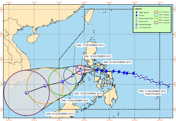
Forecast track of Typhoon Nona as of Tuesday, 7 a.m. PAGASA
Public storm warning signals are still raised over areas in southern Luzon and the Visayas.
Signal No. 3 (121 to 170 kph winds expected in 18 hours)
- Mindoro provinces
- Lubang Island, Marinduque
- Romblon
Signal No. 2 (61 to 120 kph winds expected in 24 hours)
- Burias Islands
- Southern Quezon
- Batangas
- Calamian group of islands
Signal No. 1 (30 to 60 kph winds expected in 36 hours)
- Metro Manila
- Masbate including Ticao Island
- Camarines Sur
- Camarines Norte
- Albay
- Cavite
- Laguna
- Bulacan
- Rizal
- Northern Palawan
- Bataan
- Rest of Quezon
- Aklan
- Capiz
- Antique
- Iloilo
The typhoon is expected to bring heavy to at times intense rainfall within the 250-kilometer diameter of the typhoon.
SINIRA NI NONA ANG BAHAY NAMIN :'( :'( :'( LORD PLEASE HELP US!
Posted by Emil Catunhay Aniban on Sunday, December 13, 2015
PAGASA also warned against flash floods and landslides over the areas under signals no. 2 and 3, while storm surges of up to 3 meters are possible.
AccuWeather Meteorologist Adam Douty said "Nona" will continue to weaken as it crosses the central areas of the Philippines into Tuesday, but its damaging wind gusts at over 130 kph will target the rest of souther Luzon.
"[Nona] is a very compact typhoon, so that will prevent its most devastating impacts from extending too far from its center," Douty said in a report Tuesday.
He said Metro Manila is likely to be affected by heavy rainfall, even as strong winds are expected to bypass the country's capital.
The weather agency says the cyclone system is forecasted to be at 205 kilometers northwest of San Jose, Occidental Mindoro by Wednesday morning, and will continue to head 270 kilometers west of Coron, Palawan on Thursday.


- Latest
- Trending